Cooler weekend on tap
INDIANAPOLIS (WISH) — Quiet start to the weekend, with spotty showers returning to the forecast on Sunday.
Saturday:
Mostly cloudy conditions with cooler, but slightly above normal temperatures for the middle of March. Highs top out in the middle 50s across the area.


Saturday night:
Mostly cloudy. Temperatures should be slightly warmer compared to this morning. Lows fall to the upper 30s and lower 40s.

Sunday:
Approaching storm system from the west will bring an increase in cloud cover through the day. Can’t rule out a few spotty light showers across the area as well. Highs hit the lower 50s.


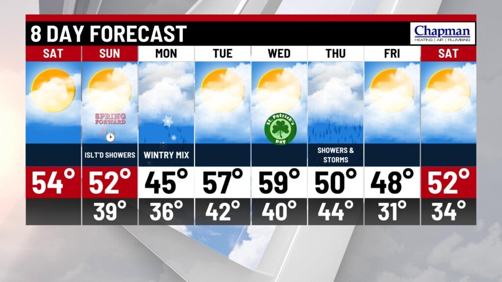
8 day forecast:
Potent winter storm system that will dump heavy snow in portions of Colorado and Wyoming this weekend, will push into the Midwest starting Monday. Morning showers will possibly mix with sleet, snow and freezing rain. Any icing should be very limited for the morning drive, but could lead to some slick spots on elevated surfaces. Any frozen precipitation will transition to all rain by late morning into the afternoon.


Temperatures will jump to the mid 50s for Tuesday, and could approach 60° for Wednesday. Showers and even some thunderstorms will be possible Thursday. We’ll see temperatures fall back to seasonal normals by the end of the week into the weekend.