


Bundle up for possible single-digit temps overnight
INDIANAPOLIS (WISH) — Another Alberta clipper weather system moved through Indiana on Sunday. Most areas saw a dusting to a quarter inch of light snow. The light snow will be ending by this evening. Watch out for slick spots as temperatures drop this evening and overnight.
Tonight: Partial clearing and very cold. Low 10.
Monday: Very cold to start so bundle up if you are headed out to work or school. Some sunshine will lift the temperature to 32 by afternoon.
Tuesday: Mostly sunny and much warmer. High 45.
Late this afternoon, the snow showers have ended north of Indianapolis and the skies are clearing. But, snow continued south of I-74

The area of snow showers moved into central Indiana a little after noon. Most areas received a quarter of an inch or less. Some spots could end up with a half-inch or so.

The snow will be moved out well before 10 p.m. Sunday. Then, skies will clear and temperatures will drop.

In areas that received a new covering of snow, temperatures will be down to single digits Monday morning.

Be sure to bundle up if you are headed out early Monday. Not real wind, just real cold.
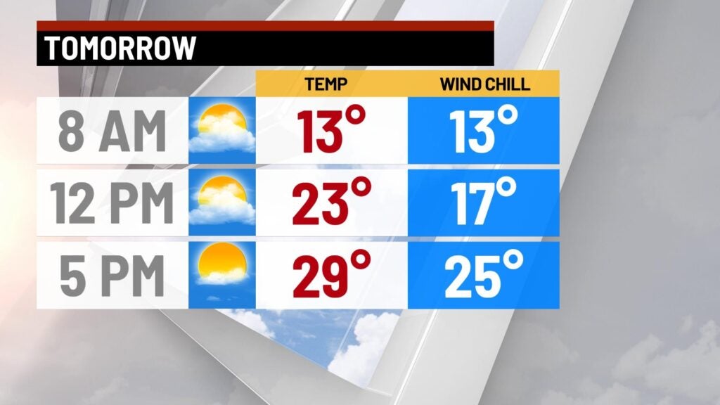
We will finally see some sunshine, and we will need it, to warm temperatures to 32 by Monday afternoon.

8 Day Outlook: Unseasonably warm temperatures stick around until late Thursday. With the warm air, we will increase chances of rain showers Wednesday afternoon into Thursday morning. On Thursday afternoon, as colder air moves in, the precipitation may change to a little snow. Then, about-average temperatures will extend into next weekend: 20s overnight and highs in the 40s.
