


One more hot day; late week heavy rain threat

INDIANAPOLIS (WISH) — Another round of 90° heat is on tap for Wednesday. Remnants of Gordon could make for a soggy stretch this upcoming weekend.
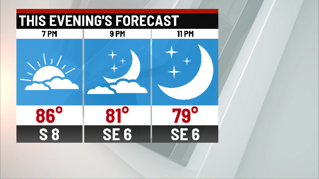
Tonight:
A few isolated storms have developed during the afternoon hours. While some locally heavy downpours are possible, they will be few and far between. Any rain chances will diminish by mid evening.

Overnight should be quiet, warm and muggy. Lows dip to the lower to middle 70s.

Wednesday:
Similar to the past few days – dry start and humid start to the morning. Hot and humid afternoon, with a few pop up storms possible. Highs top out in the upper 80s and lower 90s.

Thursday:
Cold front approaching from the northwest should bring a better chance for rain across the area – as early as just before daybreak, Thursday. The rest of the will be left with scattered showers and storms on and off through the day.

Temperatures should fall back just a bit, with highs in the middle 80s.
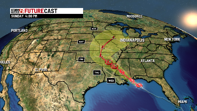
Heavy rain potential:
The remnants of Tropical Storm Gordon will move through the central Plains, and into the Midwest as early as Friday evening, and likely through much of the weekend. Heavy rain will be possible in the time period between Friday night and Sunday morning. Some minor flooding issues could be possible – but overall, many places are pretty dry and could use a good soaking. Rain chances look to wrap up by late Sunday, opening up for a dry start to the work week. This forecast isn’t set in stone, as the track could change a bit over the next few days – keep updated with the forecast especially if you have outdoor plans Friday night and/or this weekend.
8-day forecast:
Thursdays cold front will bring some much welcomed relief from the high heat. Temperatures may only hit the middle 70s over the weekend, and will finish the extended forecast near normal with highs in the lower 80s ealry next week.
