Summer-like Saturday, storms return Sunday

INDIANAPOLIS (WISH) — Our half and half weekend trend continues, with strong storms possible to end the weekend.
Today:
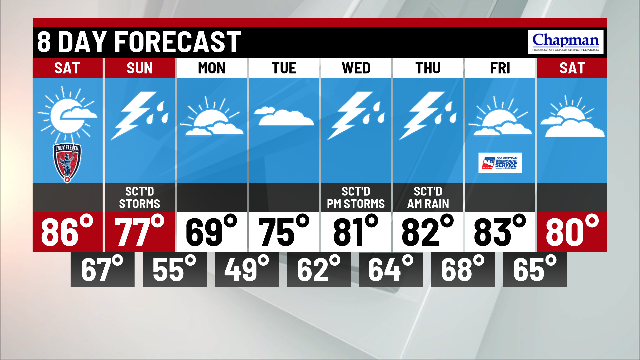
Beautiful weather is on tap for Saturday. Summer-like heat will move in, bringing the warmest temperatures of the year so far this year to the area. Highs will top out in the mid 80s this afternoon.


Tonight:
Watch for increasing clouds ahead of our Sunday system. A few showers will roll into western Indiana just before daybreak. Muggy lows will only slip to the middle 60s.


Sunday:
A potent system will eject from the Plains into the Midwest. A weakening storm complex from the overnight will pass through central Indiana Sunday monring. We’ll catch a brief break before a cold front triggers a strong line of storms into the state for the afternoon.
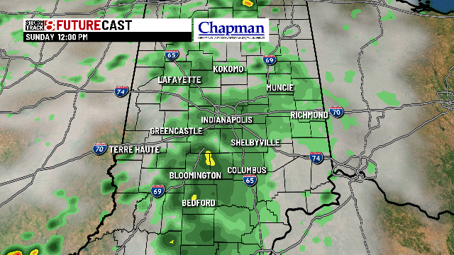

Much of the state is under a slight risk for severe storms. All modes of severe weather are in play, with damaging wind the primary concern.

Highs will run a bit cooler, topping out in the middle 70s.

8 day forecast:
There will be much cooler air behind Sunday’s front. Highs will hit the upper 60s Monday afternoon with dry conditions. It should remain quiet through Tuesday night and Wednesday morning. Showers and storms will make a return to the forecast for Wednesday afternoon through Thurday morning, as we slowly climb back to the 80s for the second half of the week.