


The big cool-down has arrived, but how long will it last?

INDIANAPOLIS (WISH) — Good Thursday morning, everyone! We’re off to a cool, dry and breezy start. No need for the rain gear, but you might want a jacket or sweatshirt.

Temperatures will be slow to climb thanks to a stiff west-northwest wind.
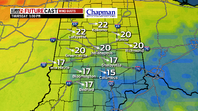

Highs will eventually top out in the mid to upper 50s with some sunshine.

These high temps will be roughly 10 degrees below where we should be for this time of year.

With mostly clear skies and a north wind tonight, temps will fall off fast. We’ll bottom out in the mid to upper 30s by daybreak Friday. Better find that winter coat!


We’ll stay dry for the Friday morning commute, but stash the umbrella in the back seat for the evening commute as rain returns by 3-4 p.m. and hangs around through Friday evening.

High temps Friday will be similar or even cooler than this afternoon.


If you’re heading to high school football this Friday evening, bundle up as temps will fall off quickly. You might also make sure to wear something waterproof.

The weather will improve slightly this weekend with highs returning slowly to the low 60s with more sunshine.

The homecoming match-up between the Hoosiers and the Hawkeyes will be a cool one with a kickoff temperature in the upper 40s.

Temps will remain at or below average for the next 8 days.

Outside of stray storms the next few days, better rain chances will hold off until early next week.


Behind our next wave of rain, temperatures will rebound a bit towards the tail end of next week with highs in the mid to upper 60s by next Thursday.