Tracking Thursday’s storms, much colder air to briefly follow
INDIANAPOLIS (WISH) — After enjoying a fantastic Wednesday, we’ll turn our attention towards on and off showers and storms for Thursday. Some of the storms may become strong to severe. Then, a shot of fairly cold air will settle in briefly before another warmup slides in.
Wednesday night: Clouds are expected to increase this evening ahead of our next weather system. Showers and storms will move in during the overnight hours into early Thursday morning.


Lows will fall into the mid 40s. Areas to the north will slip into the 30s while locations south of Indy look to hold in the 50s.

Thursday: Expect a damp morning commute with on and off showers and storms continuing. By late morning Thursday into the early afternoon hours, there could be re-development of activity, and this batch of development will be watched carefully for stronger storm potential. Thursday night could even see snow showers mainly north of interstate 70 as colder air moves in.


There remains the risk for isolated strong to severe storms from the late morning to early afternoon hours. The Enhanced Risk (level 3/5) has dropped southward a bit from this morning’s risk update. A good portion of central Indiana is in a Slight Risk (level 2/5) for strong to severe storms. Damaging winds are the primary threat, but we cannot rule out an isolated tornado mainly south of interstate 70.

Highs are going to vary across the state due to the passage of the low pressure system. Areas south and east of Indy look to sneak into the mid 60s. Meanwhile, areas to our north and west will be in the 40s and 50s.


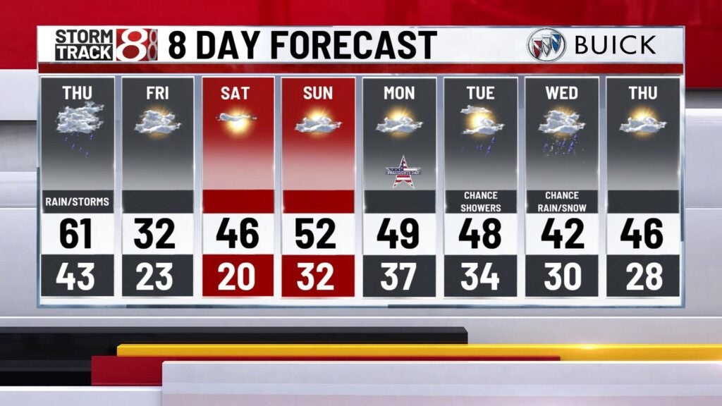
Friday: Thursday’s system will cause a temperature whiplash for Friday as we go from warm to fairly chilly air in a short amount of time. Winds will stay breezy as highs only make it into the low 30s. This will cause rather cold wind chill values in the teens to mid 20s.

8-Day Forecast: We’ll quickly bounce temperatures back into the mid 40s for Saturday after a cold end to the workweek. Sunday will be even warmer with highs pushing into the low 50s. Breezy winds will also continue throughout the weekend as well. Additional rain chances look to move in by early next week.