


When we look to see relief from the heat
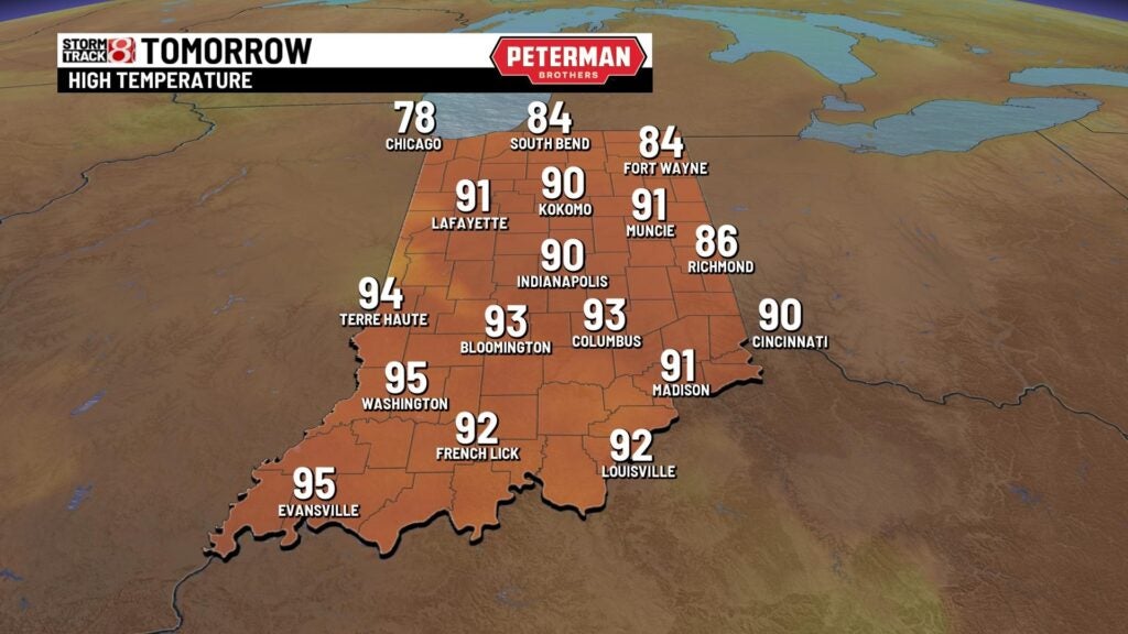
INDIANAPOLIS (WISH) — We had another round of hit and miss storms statewide with some locations once again hitting the 90s. This hot and active weather pattern is set to last for the remainder of the week. Then, relief from the heat settles in this weekend.
Wednesday night: A few spotty storms remain possible going into and through the overnight hours. Expect another warm and humid night with lows falling into the low to mid 70s.


Thursday: More hit and miss showers and storms are ahead for our Thursday with heat and humidity staying in place.


Isolated strong to severe storms are also possible from a Lafayette-New Castle line south. Damaging winds are the primary threat.

Highs look to top out in the low 90s.

Friday: Have the rain gear handy as on and off storms are likely throughout the day. There is the potential for isolated strong to severe storms for mainly the southern third of the state with damaging winds as the main threat. Flooding concerns could arise as well.


Slightly cooler temperatures are expected with highs rising into the mid 80s.

8-Day Forecast: A few showers may stick around into Saturday morning before we work in much more comfortable air for the weekend. Enjoy low humidity values, bright skies, and highs in the low to mid 80s. Hot air returns for the first half of next week. Additional storm chances are possible next Tuesday.
