


45 years later: Blizzard of ’78
INDIANAPOLIS (WISH) — Forty-five years ago, in late January 1978, the Ohio Valley and Great Lakes regions experienced a once-in-a-lifetime blizzard that crippled the aforementioned regions and set records that still stand to this day.
The devastating impact this event had on those that were affected from mainly Jan. 25-27 could not be fully foreseen. Even forecasters themselves who gave the warning that this big system was on its way were bewildered at its results.
System setup: A strong low pressure system and arctic airmass was dropping southward out of Canada into the northern plains on Jan. 24. At the same time, another low pressure system in association with a disturbance embedded with the subtropical jet stream across the southern United States was taking shape over eastern Texas.

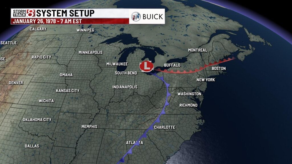
These two systems would undergo a rare merger. This merger would lead to an explosive intensification of the surface low over Alabama and Georgia on Jan. 25 before racing towards the Great Lakes region. The system’s center pressure would end up dropping a remarkable 40 millibars in just 24 hours, and this led way to all-time low barometric pressure readings. More on those pressure readings will be addressed in the stats section of this story.
NWS Indianapolis would end up having to issue their first ever blizzard warning at 3:45 p.m. EST Jan. 25. Twelve hours prior to this issuance, a heavy snow warning was in place. Blizzard warnings also extended through much of Ohio and into Michigan.
Transition to prolonged snow: Precipitation begin as a wintry mix in Illinois, Indiana, Ohio and Michigan on Jan. 25 before a changeover to all snow took place in the early morning hours of Jan. 26. Once the changeover to snow occurred, conditions spiraled out of control in a hurry. Temperatures would plummet from the 30s and 40s into the single digits in a matter of a couple hours.
Winds would also begin to howl with gusts eventually pushing up to or well over 50 mph. These high winds combined with the heavy snow reduced visibilities to under a quarter-mile at times. Wind chill values also became very brutal with negative 50 degrees to negative 60 degrees feels-like temperatures transpiring across Indiana and Ohio.
Speaking of the high wind gusts, there were some locations in Ohio that saw fierce gusts of over 70 mph. Here were some of the highest gusts in Ohio on Jan. 26:
- Dayton, Ohio, 69 mph.
- Cleveland, 82 mph.
- Near Sandusky on Lake Erie (Ore Carrier), sustained winds of 86 mph and gusts up to 111 mph.
The aforementioned deteriorating conditions created a widespread dire situation with power outages, people stranded, snowdrifts from 20-25 feet, and structural damage.
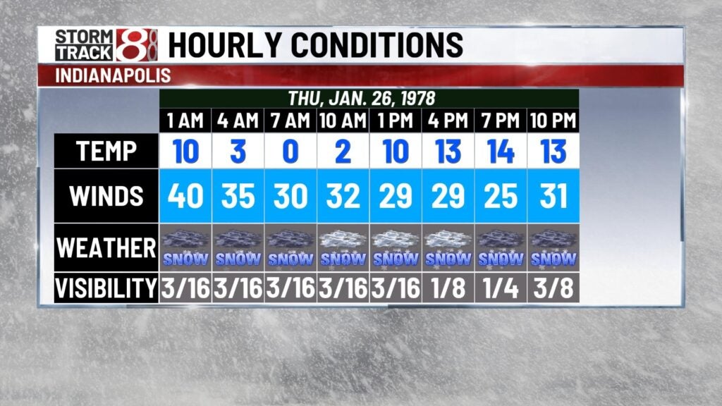
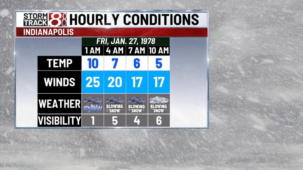
To show how drastic the weather changed from Jan. 25-27, here is what Indianapolis’s observations were in that timeframe.

Final snow totals and stats: Breaking down the final stats from this blizzard always stuns us in a way that can’t be described. The snowfall by itself was simply incredible in which Muskegon, Michigan, saw the highest amount of snow in this event at a remarkable 52 inches. Part of this total was also influenced by lake-effect snow.
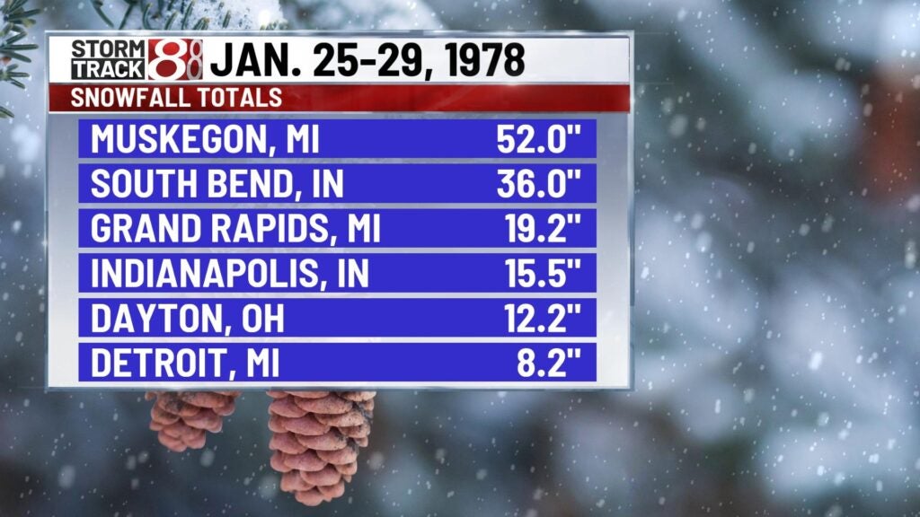
Here in Indianapolis, we officially received 15.5 inches of snow. Areas in northern Indiana and southern Michigan were especially buried by snow with totals even over 3 feet in spots. Indianapolis also had 4.5 inches on the ground before this event, and this created an unfathomable and record-breaking snow depth of 20 inches for the city. A staggering note from the National Weather Service at Indianapolis states that significant snowfall lasted for about 31 hours.

On top of record-breaking snow, record low barometric pressures were observed. To start, Mount Clemens, Michigan, saw a pressure of 956 millibars, which still stands as the third-lowest atmospheric pressure recorded in the mainland United States. The lowest pressure overall in this event took place in Sarnia, Ontario, at 955.5 millibars. Other locations listed below also saw record minimum surface pressures:
- Fort Wayne, Indiana – 975 millibars.
- South Bend, Indiana – 976 millibars.
- Columbus, Ohio – 963.8 millibars.
- Dayton, Ohio – 971.2 millibars.
- Cincinnati – 975.6 millibars.
- Cleveland – 957.7 millibars (lowest on record for Ohio).
This system unfortunately caused over 70 confirmed deaths. Ohio would end up having 51 of those fatalities with many losing their lives due to being exposed to the elements.
It should also be mentioned that former and legendary WISH-TV meteorologist Stan Wood would nail the Blizzard of 1978 forecast and helped with two to three days straight of coverage.
Impacts: Daily life was altered in a way that hardly anyone could’ve imagined. Many people were stuck at wherever they were at for days with roads being impassible. Highways were also clogged with stranded motorists. All across the region, thousands of volunteers with snowmobiles and four-wheel drive vehicles risked their lives to transport emergency personnel and utility workers and to deliver medical necessities to those in need. Even classes at the Ohio State University and the University of Notre Dame were closed for the first time ever at those schools. All-in-all, many areas were buried by snow.
Here in Indiana, the governor sent National Guard tanks onto I-65 to remove stranded semis.
A snowbank stalled a seven-car Amtrak train in Putnam County. Indiana.
Bell was forced to halt all phone traffic but emergency calls.
In Franklin, the Daily Journal published on pink paper, explaining that the color would help readers find their papers in the snow.
The governor declared a snow emergency for the entire state the morning of Jan. 26.
During the afternoon of Jan. 26, the Indiana State Police considered all Indiana roads closed.
In Ohio, nearly all schools were able to thankfully be canceled on Jan. 26. Thousands of men and women on active duty put in many long hours to help clear roadways, restore power, perform emergency rescues and evacuations, deliver food and medicine, and transport medical personnel to hospitals. In many instances, the only means of rescuing individuals with medical emergencies was by helicopter. Radio stations suspended regular programming to provide storm information and to serve as communication links where other means of communication had failed and highway travel was impossible.
Many trees and powerlines were also down due to the very high winds across the Ohio Valley and Great Lakes. As a whole, this is not only the worst blizzard to hit Indiana and Ohio, but one of the worst on record in the mainland United States. Below are some photos that viewers sent in to WISH-TV to share their memories of this historic event.


