


Baseball-sized hail threatens Texas again as flood risk increases
(CNN) — An outbreak of severe storms is threatening more than 33 million people in the southern Plains, while the risk for flash flooding ramps up Tuesday and Wednesday.
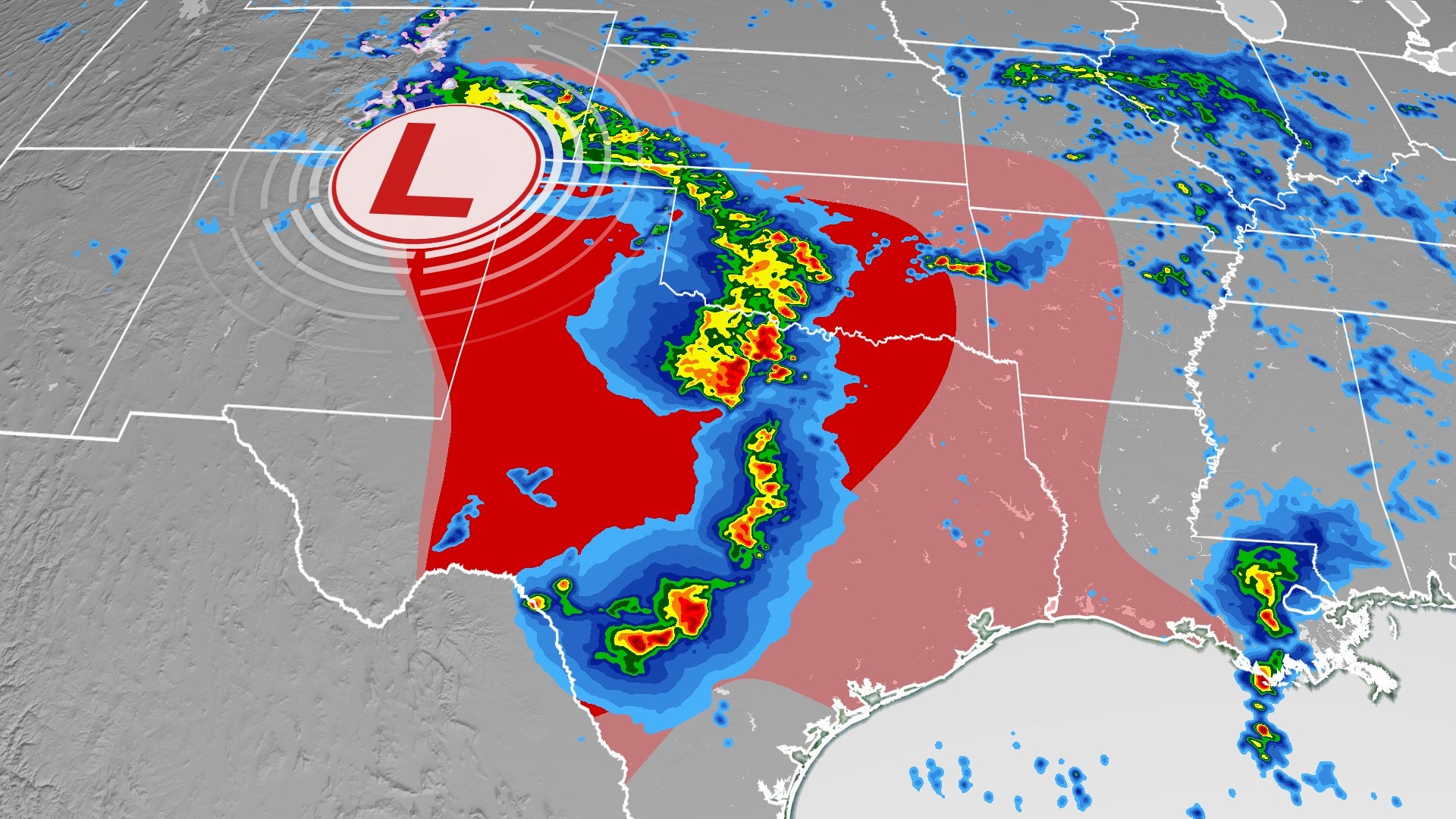
Hail is the greatest risk associated with Monday’s storms in Texas. “Destructive giant hail is possible, if not likely,” the National Weather Service (NWS) office in Midland said.
Hail as large as baseballs could fall on a state that has already witnessed damaging hail events within the past month.
The misery for millions came Monday afternoon. Extremely heavy rain, between 7 and 14 inches, has fallen across portions of southeastern Texas and southwestern Louisiana and led to flash flooding across the region.
Severe hail and damaging winds
A level 4 out of 5, “moderate” risk for severe weather is in place for parts of West Texas, including Abilene and Lubbock. This is the region at most risk for severe hail, but that threat spans from Colorado to Kansas and through coastal sections of Texas and Louisiana. Dallas, Fort Worth, Oklahoma City, Denver, Houston, Amarillo and San Antonio are included in the threat zone into Monday night.
Showers and thunderstorms swept across northeastern portions of Texas this morning, bringing heavy rain and frequent lightning, but severe weather is not a major concern with this round of storms.
That was to change beginning Monday afternoon, however, as scattered thunderstorms rapidly form over portions of West Texas and eastern New Mexico and Colorado. This is where the moist, humid air from the Gulf of Mexico meets the very dry air from the desert Southwest.
These storms will be responsible for the large hail, but there is also a risk of tornadoes. The systems, especially in the first few hours of their formation, will be supercells. This type of storm spins and can sometimes produce tornadoes.
Tonight, these supercell thunderstorms are expected to evolve into a line of storms pushing east across much of Oklahoma and northern Texas. This line will need to be watched for damaging, straight-line winds, with gusts of up to 60-70 mph. Storms will be possible farther south into central Texas.
This is an overnight threat, so it is important to have weather alerts set on your phone in case any dangerous weather moves through your town. It’s not until Tuesday morning when this first round of storms will weaken once it reaches Arkansas.
More than 30 million face flooding risk
Flooding will increasingly be a concern through portions of the Deep South this week. More than 30 million people are under flood alerts from the Hill Country of Texas through the Dallas metroplex and northward to central Oklahoma. There are also alerts in parts of Arkansas and much of Louisiana.
A flash flood emergency has been issued for western Jefferson County in Texas and eastern Calcasieu Parish in Louisiana, which includes the city of Lake Charles.
The Calcasieu Parish Sheriff’s Office in Louisiana urged residents to stay off the roads after heavy rains in the area. The sheriff’s office said in a Facebook post Monday the “roadways and conditions are deteriorating and changing quickly.”
The National Weather Service is calling this a “particularly dangerous situation” and advises people to move to higher ground.
The NWS warns of “Life-threatening flash flooding of creeks and streams, urban areas, highways, streets and underpasses.”
A flash flood watch has also been issued across much of this area through Thursday evening where even more rounds of rain are forecast.
“Total rainfall amounts of 5 to 10 inches with locally higher amounts of 15 inches can be expected today through Thursday afternoon,” the weather service said.
Southerly winds on the south side of a frontal boundary will usher in an abundance of tropical moisture through the week, inundating these areas with consistent rainfall and the potential for flooding. In addition many of the storms that will be firing up will be slow movers, making risk of flooding more severe.
Several rivers and creeks are already at at moderate flood stage, with several experiencing rapid rise. A location along the Sabine River, just northeast of Dallas, saw a 12-foot rise in less than 24 hours — and this was the second time it’s happened in less than a week.
The heaviest rain is forecast for Tuesday and Wednesday, where there is a level 3 out of 4 for the risk for flash flooding. This includes Dallas, San Antonio, Austin and Houston. Several locations in Texas could see more than 5 inches of rain.
The biggest forecasting challenge is determining where the heaviest rain will fall. “It seems pretty safe to say that somebody, somewhere in the eastern half of Texas is going to get slammed with a lot of rain,” said the National Weather Service office in Houston.
“The potential for minor flooding due to slow-moving storms producing heavy to torrential rainfall is also possible, though knowing an exact location for it is still hard to tell.”
Severe threat continues much of this week
Early Tuesday, a secondary round of thunderstorms is expected to develop across west-central Texas, tracking east while intensifying. This will put central and northeastern parts of Texas at risk for strong storms through Tuesday afternoon. Large hail and damaging winds will be possible with these storms.
Scattered thunderstorms are possible across the remainder of the southern Plains on Tuesday afternoon before a potential third round of intense thunderstorms develops in the evening across central Texas and Oklahoma and continuing into Tuesday night.
The exact location and intensity of these storms is uncertain since this forecast depends on what happens with Monday’s storms. Dallas, Fort Worth, Oklahoma City and Austin will need to be on the lookout, regardless.
The weather pattern fueling these days of severe weather will be rather stuck, so additional thunderstorms, some of which could be severe, will continue to threaten the southern Plains much of this week.