Reflecting back on the June 2012 North American derecho

INDIANAPOLIS (WISH) — On this day ten years ago in 2012, a widespread and extremely destructive line of storms roared across the midwest, Ohio valley, and mid-atlantic. This would become known as the “midwest derecho” in which it wreaked havoc for nearly an entire day.
Throughout the month of June in 2012, Indiana and surrounding areas in the midwest were gradually building in an oncoming heat wave that had started in the southwestern United States. By the time we got to the final week of the month, Indiana was seeing unprecedented record-breaking temperatures with numbers rising into the mid-100s. On Thursday, June 28th, Indianapolis would set the all-time record high for June with a staggering temperature of 104°. This exceptionally dangerous heat was quietly leading way to a rather explosive end to the week.
Friday, June 29th, started off very warm for the entire midwest with temperatures set to quickly rise back into the triple digits. During the morning hours, a small thunderstorm formed in central Iowa and gradually grew in size as it went into Illinois. At this time, this storm complex remained mostly below severe limits. However, things would drastically change as the complex’s severe weather capabilities widened near Chicago closer to the early afternoon hours. Once the complex got into Indiana, it officially became a derecho.
The northern half of Indiana would then encounter significant wind gusts during the early afternoon hours. Fort Wayne, Indiana would see the highest wind gust of the entire event, peaking at 91 MPH. By this point, the system was taking on a well-defined bow echo shape. The derecho continued to charge into Ohio at a forward speed of roughly 60 MPH to the east-southeast, and this speed was maintained for much of the remainder of its life. Since this complex was expected to last a lengthy amount of time, an upgrade to a moderate risk was put into place just before 4 PM EDT.

Numerous wind gust measurements of over 80 MPH were recorded in Ohio. Severe damage to the power grid in portions of central Ohio had also occurred.
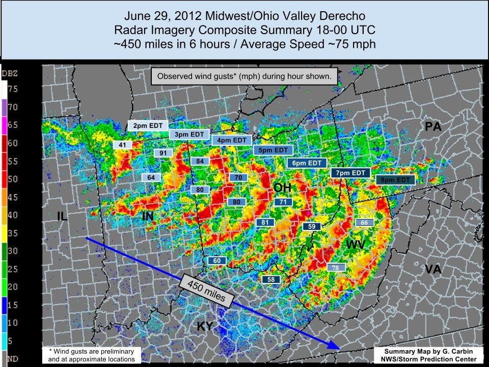
Widespread wind damage would continue to unfold through West Virginia, northern Kentucky, and southwestern Pennsylvania during the early evening hours. Despite the mountainous terrain of the Appalachian mountains and loss of daytime heating, the highly unstable airmass kept this complex together and intense going into the nighttime hours. Widespread wind gusts of over 70 MPH were measured through heavily populated areas such as Richmond, VA and the Washington D.C. area. A wind gust of 87 MPH was even recorded in Baltimore-Washington metropolitan area. Destructive winds were still charging through Chesapeake Bay and into the Atlantic ocean after midnight EDT into June 30th. The highly destructive and long lived derecho finally dissipated completely at 4 AM EDT just south of Long Island, New York.
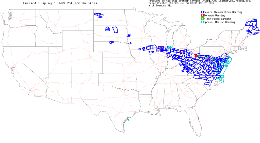
The long trail of destruction left behind was unfortunately quite incredible. Thousands of trees were either uprooted or snapped, roofs were damaged, tents on display for 4th of July fireworks were collapsed, and over 4.2 million people lost power. Damage costs were up to a mind-blowing 2.9 billion dollars. The derecho tracked for 800 miles, lasted 18 hours, and killed 22 people. In order to have a derecho, you must have a line of storms with damaging wind reports that has traveled for at least 250 miles. This one in particular will certainly never leave the minds of those who had to encounter nature’s violent fury that day.