


Storm Track 8 blog: Storms lead to weather alerts in central, northern Indiana
INDIANAPOLIS (WISH) — Here are the latest updates on Wednesday night storms across Indiana, from the National Weather Service and Storm Track 8.
9:38 p.m.
Clinton County 911 reports Frankfort City Light & Power outages will persist for the next 2-4 hours for customers in its eastern area.
8:31 p.m.
A strong thunderstorm will impact portions of Wayne, Union and east central Fayette counties in Indiana, plus five Ohio counties, through 9:15 p.m. Primary hazards are 40 mph gusts, pea-sized hail, frequent lightning, and very heavy rain.
8:29 p.m.
A strong thunderstorm will impact portions of eastern Allen and northeastern Adams counties in Indiana, plus two Ohio counties, until 9:15 p.m. Primary hazard is 50 mph gusts.
8:10 p.m.
A strong thunderstorm will impact portions of northwestern Elkhart County, eastern St. Joseph County, northeastern Marshall County, and two counties in Michigan through 9 p.m. Primary hazard is 50 mph gusts.
8:08 p.m.
A strong thunderstorm will impact portions of northwestern St. Joseph County and northeastern La Porte County in Indiana, and Berrien County in Michigan through 9 p.m. EDT/8 p.m. CDT. Primary hazard is 50 mph gusts.
8:03 p.m.
A storm thunderstorm will impact portions of northeastern Franklin County, Wayne County, Union County and eastern Fayette County in Indiana, plus two counties in Ohio, through 8:30 p.m. Primary hazards are 35 mph gusts, pea-sized hail, frequent lightning and very heavy rain.
7:57 p.m.
7:40 p.m.
A strong thunderstorm will impact portions of southeastern Steuben, northeastern Allen, and De Kalb counties in Indiana, plus northwestern Defiance and
southwestern Williams counties in Ohio through 8:15 p.m. Primary threats are 50 mph gusts and pea-sized hail.
7:38 p.m.
A strong thunderstorm will impact portions of northwestern Fulton and Marshall counties through 8:15 p.m. Primary threats are 50 mph gusts and pea-sized hail.
7:33 p.m.
Clinton County 911 reports a downed tree has closed Haven Avenue and Maranatha Drive along South Malish Road on the east side of Frankfort.
7:28 p.m.
A severe thunderstorm warning was in effect until 8 p.m. for eastern Cass and western St. Joseph counties. Primary threat is 60 mph gusts and penny-sized hail.
A severe thunderstorm remains in effect until 6:45 p.m. CDT for northern Lake County.
7:18 p.m.
Storm Track 8 meteorologist Steven Diana and Chief Meteorologist Ashley Brown give an update on the storms on Facebook Live.
7:15 p.m.
The severe thunderstorm warning for northern Lake County will continue through 6:45 p.m. CDT.
7:03 p.m.
A severe thunderstorm warning was in effect until 7:45 p.m. for eastern Allen County and northern Adams County in northeastern Indiana. Primary hazard is 60 mph gusts.
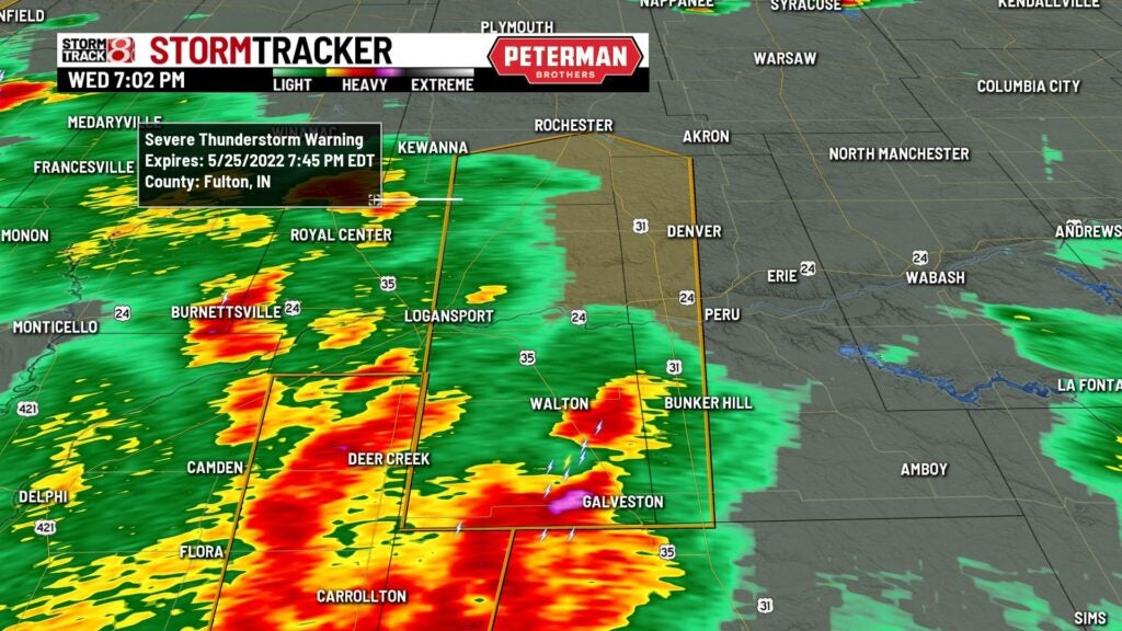
7 p.m.
A severe thunderstorm warning was in effect for Cass, western Miami, and southwestern Fulton counties until 7:45 p.m. Movement is north at 50 mph. The main threat is 60 mph gusts and isolated gusts up to 70 mph.
6:55 p.m.
A severe thunderstorm warning for eastern Carroll County, and northwestern Howard County until 7:30 p.m. The main threat is 70 mph gusts.
6:44 p.m.
6:33 p.m.
A severe thunderstorm warning for southeastern Lake County Indiana and three Illinois counties until 6:15 p.m. CDT. The main threats are 60 mph gusts and penny-sized hail.
6:30 p.m.
A severe thunderstorm warning for southeastern Carroll County, central Clinton County, west central Howard County, and northeastern Boone County until 7 p.m. The main threat is is 60 mph gusts.
6:15 p.m.
A severe thunderstorm warning for northeastern Hendricks County and Boone County until 6:45 p.m. The main threat is is 60 mph gusts.
6:13 p.m.
The National Weather Service says a storm over Brownsburg, Lebanon, and Pittsboro continues and will produce 55 mph winds until 6:45 p.m.
6:00 p.m.
The National Weather Service says a storm over Anderson, Elwood, and Alexandria continues and will produce 50 mph winds until 6:30 p.m.
5:49 p.m.
The National Weather Service says a storm over Greenfield, Pendleton, and Fortville continues and will produce 50 mph winds until 6:15 p.m.
5:49 p.m.
The National Weather Service says a storm over Anderson, Pendleton, and Lapel continues and will produce 60 mph winds and possible penny-sized hail until 6:00 p.m.
5:42 p.m.
The National Weather Service says a storm over West Lebanon, Judyville and Marshfield will produce 60 mph winds until 6 p.m.
5:36 p.m.
The National Weather Service says a storm over Anderson, McCordsville, and Pendleton will produce 60 mph winds and penny-sized hail until 6 p.m.
5:33 p.m.
The National Weather Service says a storm over Anderson and McCordsville will produce 40 mph winds until 6 p.m.
5:29 p.m.
The National Weather Service says 40 mph winds for Morristown and Manilla until 6 p.m.
5:25 p.m.
The National Weather Service says a weather statement has been issued for New Albany, Clarksville, and Shively, Kentucky until 6 p.m.
5:15 p.m.
Storm Track 8 says that rain and storms continue to develop and move northward through central Indiana. A couple of stronger storms are moving towards Greenfield and New Castle respectively with 40 mph possible wind gusts.
5:12 p.m.
5:02 p.m.
The National Weather Service says a storm over Knightstown, Spiceland and Shirley will produce 40 mph winds and possible nickel-sized hail until 5:30 p.m.
5 p.m.
Storm Track 8 says a 40% chance exists for a tornado watch to be issued over the next couple of hours in the northern third of Indiana.