


Storm Track 8 blog: record-breaking heat to follow day, night of storms
INDIANAPOLIS (WISH) — Severe storms moved through Indiana on Monday and cooled the air during a heat advisory.
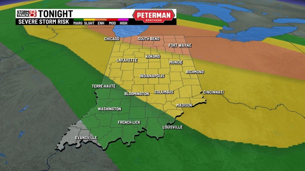
More storms were possible Monday night, as a tornado watch was issued until 11 p.m. for northwestern Indiana on Monday night. Main threats were 75 mph winds and tennis-ball-sized hail.
A severe thunderstorm watch for all of Indiana expired hours before its planned end at 10 p.m., but a new thunderstorm watch was issued for northern and north-central Indiana until midnight Tuesday.
Plus, the heat advisory remained in Indiana for only a few southern Indiana counties on Monday night.
But, it’s not over yet.
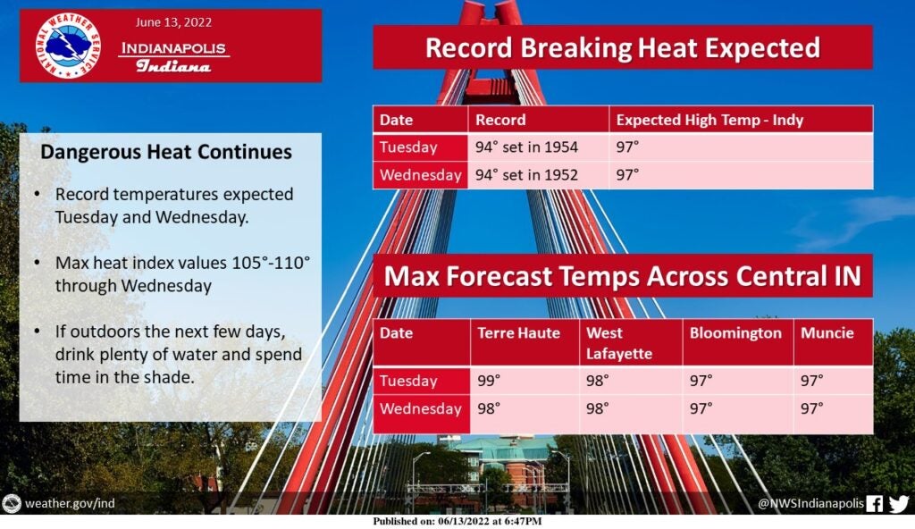
Another heat advisory will be in effect from 11 a.m. Tuesday to 9 p.m. Wednesday, as record-breaking heat is on the way. Highs look to soar into the mid to upper 90s. The record high for Indianapolis on June 14 is 94 degrees in 1954. Conditions will be quite miserable with very high humidity values leading way to peak heat index values over 105 degrees.

It is important to reiterate that the last time Indy has seen high temps over 95 degrees was in September 2013. This kind of hot weather is not typical for Indiana, and it is important for people and animals to stay hydrated and limit time outdoors. Cooling centers have been set up in Evansville, Fort Wayne, Gary and South Bend.
Follow along in our live blog for weather updates:
- Check the Storm Track 8 radar | See the Interactive Radar | Get the free Storm Track 8 weather app from the App Store | Get the free Storm Track 8 weather app from Google Play
10:31 p.m.
Here’s an update on the thunderstorm watch area.

10:27 p.m.
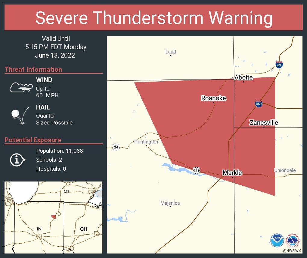
A severe thunderstorm warning was issued for Adams, Allen, Huntington and Wells counties until 11:15 p.m. Van Wert County, Ohio, also was in the warning area. Main threats were 80 mph winds and 0.75-inch-diameter hail.

10:12 p.m.
Duke Energy reports 1,719 customers without power. Most are in eastern Indiana in or near Brookville, Connersville and Liberty.
9:45 p.m.
Reports of trees uprooted or snapped and a roof blown off were received from Allen County, about 3 miles north-northwest of New Haven, the weather service says.
9:54 p.m.
A severe thunderstorm warning was issued for Fulton, Marshall, Miami, Pulaski, Starke and Wabash counties until 10:45 p.m. Main threats were 60 mph winds and 0.75-inch-diameter hail.

9:50 p.m.
A severe thunderstorm warning was issued for Allen, Huntington, Kosciusko, Noble and Whitley counties until 10:30 p.m. Main threats were 80 mph winds and hail.

9:32 p.m.
A thunderstorm watch that had include counties in far-northern Indiana was extended to additional counties: Adams, Blackford, Cass, Fulton, Grant, Huntington, Jay, Miami, Pulaski, Wabash, Wells and White. Counties already in the watch were Allen, De Kalb, Elkhart, La Porte, Lagrange, Marshall, Noble, St. Joseph, Starke and Whitley. Counties in Ohio and Michigan also were in the watch area.

9:26 p.m.
A severe thunderstorm warning was issued for Elkhart, Kosciusko, Lagrange and Noble counties until 10 p.m. Main threats were 70 mph winds, 0.75-inch-diameter hail and a possible tornado.

9:18 p.m.
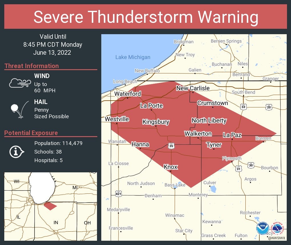
A severe thunderstorm warning was issued for La Porte, Pulaski and Starke counties until 10 p.m. Main threats were 70 mph winds and 1-inch-diameter hail. UPDATE: At 9:43 p.m., La Porte was dropped from the warning.

9:10 p.m.
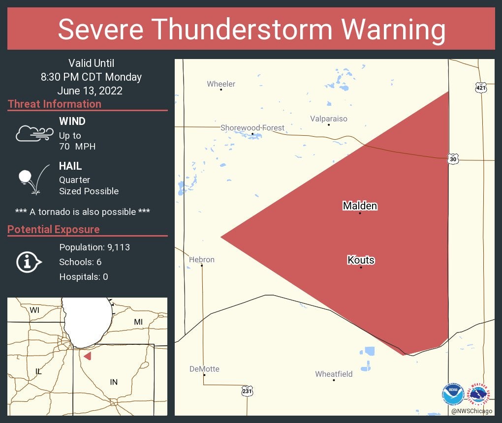
A severe thunderstorm warning was issued for Porter County until 8:30 p.m. CDT. Main threats were 70 mph winds, 1-inch-diameter hail and a possible tornado.
9:01 p.m.
A severe thunderstorm warning was issued for La Porte, Marshall, St. Joseph and Starke counties until 9:45 p.m. Main threats were 60 mph winds and hail.
8:54 p.m.
A severe thunderstorm warning was issued for Elkhart and St. Joseph counties until 9 p.m. Cass County, Michigan, is also part of the warning. Main threats were 60 mph winds and hail.

8:53 p.m.
A severe thunderstorm warning was issued for Steuben County until 9:45 p.m. Main threats were 60 mph winds and 1-inch-diameter hail. UPDATE: The collapse and partial removal of a roof was reported at 8:55 p.m. at Lake Gage, according to the Stueben County emergency manager.
8:44 p.m.
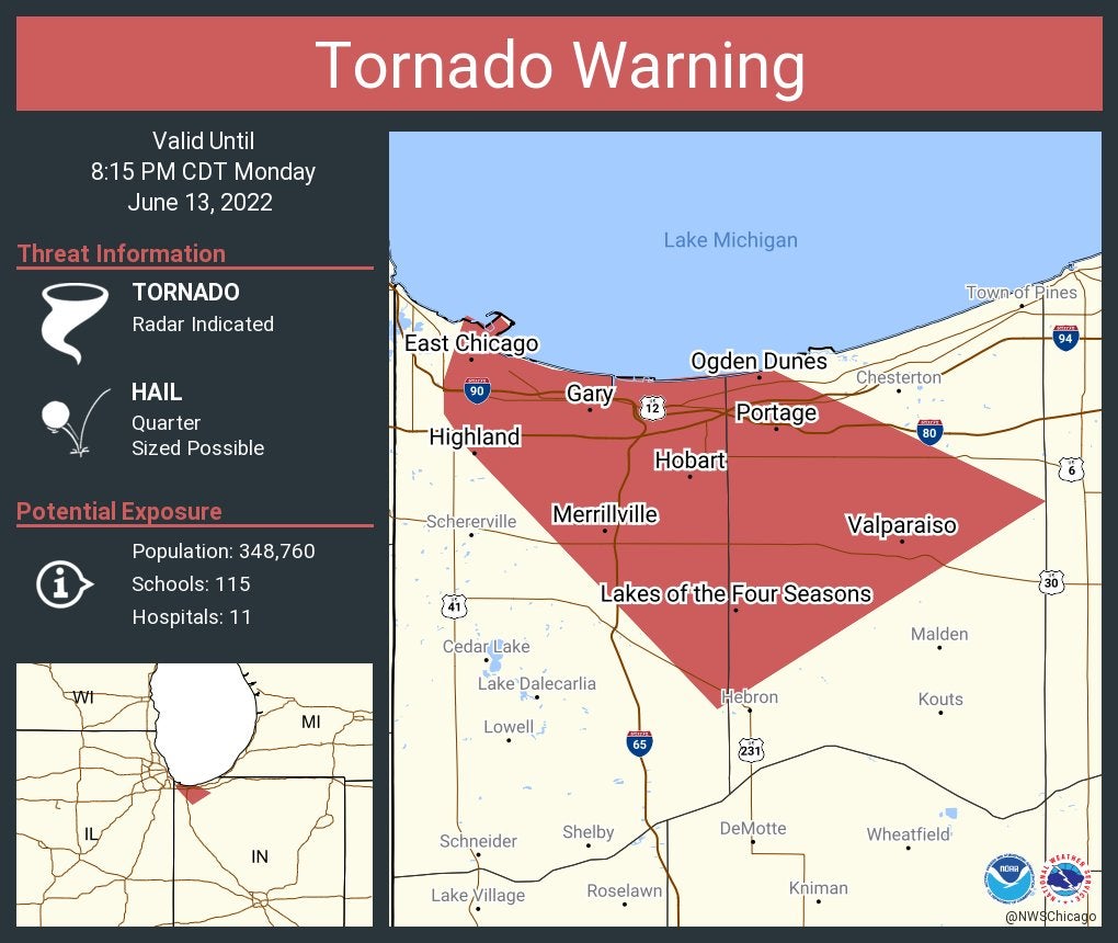
A tornado warning was issued for Lake and Porter counties until 8:15 p.m. CDT. At 7:43 p.m. CDT, a severe thunderstorm capable of producing a tornado was located over Gary. Quarter-sized hail was possible.
8:21 p.m.
A severe thunderstorm warning was issued for Elkhart and Lagrange counties until 9 p.m. Main threats were 70 mph winds, golf-ball-sized hail and a possible tornado.

6:50 p.m.
A tornado watch has been issued for parts of Illinois and Indiana until 11 p.m. CDT (midnight EST). Indiana counties included are Jasper, Lake, Newton and Porter. UPDATE: The tornado watch for Indiana counties was canceled at 9:43 p.m. EST.

6:47 p.m.
The National Weather Service at Indianapolis says, “Record breaking heat is expected tomorrow and Wednesday with highs in the mid to upper 90s. Heat indices over 105 and may approach 110 at times tomorrow. Humidity will lessen through the week as the hottest temperatures arrive. Plan ahead if you’re going to be outdoors!”
6:26 p.m.
The weather service office in northern Indiana says a new severe thunderstorm watch was issued until midnight EDT. This is for Round 2 of storms, which will likely be strongest north of U.S. 30. Damaging wind gusts of up to 80 mph are possible with storms that develop Monday night. Large hail and isolated tornadoes are also possible.

6:38 p.m.
All Indiana counties have now been removed from a severe thunderstorm watch that was initially set to expire at 10 p.m.
6 p.m.
Fort Wayne will have the lobby of the Foellinger-Freimann Botanical Conservatory open as a cooling station from 10 a.m.-5 p.m. Tuesday-Thursday. Also, The Salvation Army at 2901 N. Clinton St. in Fort Wayne will serve as a cooling station from 9 a.m.-4 p.m. Tuesday-Thursday.
5:58 p.m.
More Indiana counties were removed from the severe thunderstorm watch: Cass, Fulton, Grant, Huntington, Miami, Pulaski, Wabash and White.
5:51 p.m.
A severe thunderstorm warning was in effect until 6:30 p.m. for Adams County. Main threats are 60 mph gusts and inch-diameter hail. UPDATE: The warning expired at 6:26 p.m.
5:26 p.m.
The National Weather Service at Indianapolis says, “Pockets of flooding ongoing across Clinton, Hancock, and Rush counties as the first round of storms has exited. Additional storms are possible later this evening and tonight.”

5:16 p.m.
A severe thunderstorm warning was in effect until 6:15 p.m. for Dearborn, Ohio and Ripley counties, plus a county in Ohio and a county in Kentucky. Main threats are 70 mph gusts and hail. UPDATE: This warning was suspended at 5:57 p.m.
More counties have been removed from the severe thunderstorm watch: Brown, Clinton, Hamilton, Johnson, Marion and Tippecanoe.

5:04 p.m.
A severe thunderstorm warning was in effect until 5:30 p.m. for White County. Primary threat is 0.75-inch-diameter hail. UPDATE: This warning was suspended at 5:22 p.m.

5:03 p.m.
A severe thunderstorm warning was in effect until 6 p.m. for Decatur and Rush counties. Primary threat is 70 mph gusts and hail. UPDATE: This warning was canceled at 5:23 p.m. The Rush County emergency manager says trees and power lines were downed about 5 p.m.
A severe thunderstorm warning was in effect until 5:45 p.m. for Wayne County and two counties in Ohio. Main threat is 70 mph winds and 0.75-inch-diameter hail. A sustained wind of 58 mph was reported at Richmond, Indiana, at 5:12 p.m. UPDATE: Wayne County was dropped from the warning at 5:26 p.m.
4:59 p.m.
A severe thunderstorm warning was in effect until 6 p.m. for Dearborn, Franklin and Ripley counties. Main threats are 70 mph gusts and 0.75-inch-diameter hail.
A severe thunderstorm warning was in effect until 6 p.m. for Allen County. Main threat is 1-inch-diameter hail. The public reported nickel-sized hail at 5:09 p.m. UPDATE: The warning was suspended at 5:59 p.m.
4:57 p.m.
A severe thunderstorm warning was in effect until 6 p.m. for Fayette, Franklin, Union and Wayne counties. Main threat is 60 mph gusts and 0.75-inch-diameter hail. UPADTE: The warning will now expire at 5:45 p.m. UPDATE: This warning was suspended at 5:23 p.m.
These Indiana counties have been removed from the severe thunderstorm watch: Boone, Clay, Clinton, Fountain, Greene, Hendricks, Lawrence, Monroe, Montgomery, Morgan, Owen, Parke, Putnam, Vermillion, Vigo and Warren.
4:47 p.m.
A severe thunderstorm warning was in effect until 5:45 p.m. for Fayette, Franklin, Union and Wayne counties.

4:38 p.m.
A severe thunderstorm warning was in effect until 5:15 p.m. for Hancock, Rush and Shelby counties. Main threats are 60 mph gusts and quarter-sized hail. UPDATE: Hancock and Shelby counties were removed from the warning at 5:04 p.m. The Hancock County 911 Call Center reported at 5:50 p.m. that water was flowing over the road near the intersection of county roads 500 North and 50 East.

4:35 p.m.
A severe thunderstorm warning was in effect until 5:15 p.m. for Allen, Huntington and Wells counties. Main threats are 60 mph gusts and quarter-sized hail. at 4:48 p.m., a tree was downed in the East 2500 block of Huntington County Road 1100 North, according to law enforcement. The public reported hail with a diameter of 0.7 of an inch at Roanoke.
4:30 p.m.
A severe risk upgrade has been made for parts of northeastern Indiana as a moderate risk (level 4/5) is now in place. The threat for significant damaging winds is in place mainly northeast of a Kokomo-Richmond line. Timeline for this will be after sunset into the overnight hours.

4:12 p.m.
4:08 p.m.

4:01 p.m.
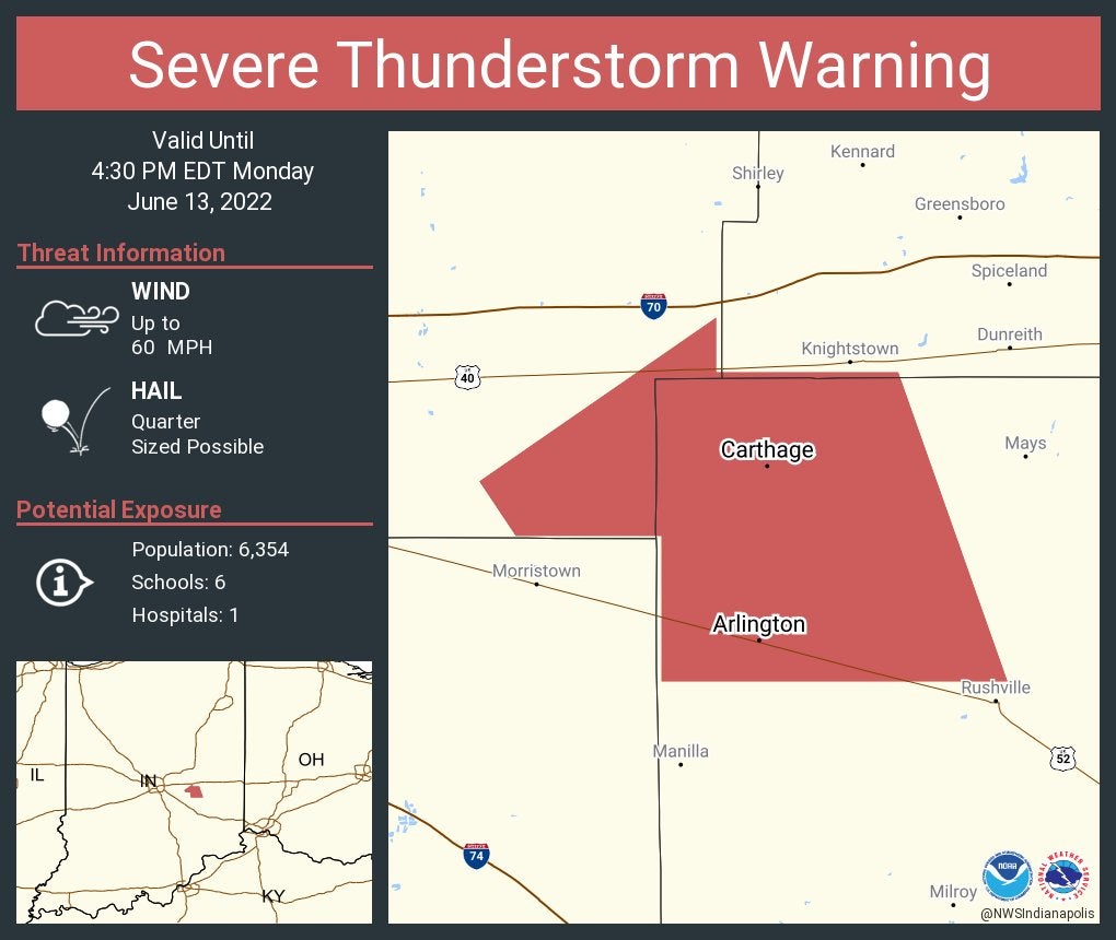
A severe thunderstorm warning in in effect until 4:15 p.m. for northeastern Shelby County, southeastern Hancock County, northwestern Rush County and southwestern Henry County. Main threats are 60 mph gusts and quarter-sized hail. UPDATE: Henry and Shelby counties were removed from the warning at 4:12 p.m., but the warning was extended to 4:30 p.m. for Hancock and Shelby counties.

3:55 p.m.
The National Weather Service tweets, “Dangerous heat continues across central Indiana with max heat index values approaching 110 tomorrow. A heat advisory is in effect again tomorrow and Wednesday. Drink plenty of water and avoid being outdoors when possible.

3:52 p.m.

3:50 p.m.

3:43 p.m.
3:38 p.m.
A severe thunderstorm warning has been issued until 4:15 p.m. for parts of Howard, northwestern Tipton, southeastern Carroll and northeastern Clinton counties. Main threats are 60 mph gusts and quarter-sized hail. UPDATE: The Howard County 911 Call Center reported several tree limbs fell in Russiaville about 3:57 p.m. The public reported 1-inch-diameter hail at 3:33 p.m. near Michigantown in Clinton County.

3:27 p.m.
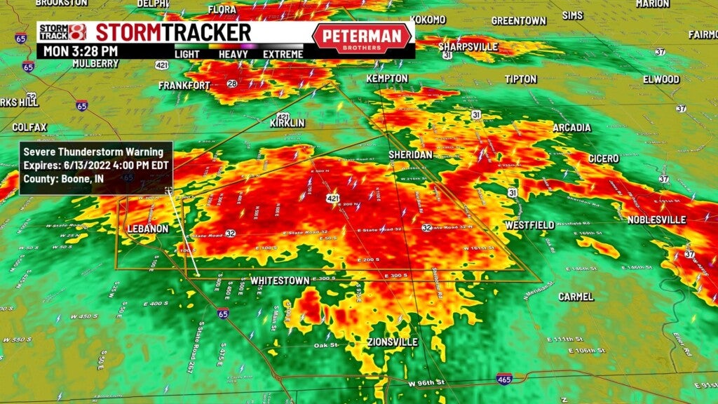
A severe thunderstorm warning is in effect until 4 p.m. for northeastern Boone and southwestern Hamilton counties. This includes the town of Sheridan and the city of Westfield. Main threats are 60 mph gusts and quarter-sized hail.
3:19 p.m.
A severe thunderstorm warning is in effect until 3:45 p.m. for Carroll, Clinton and Howard counties. Main threats are 60 mph gusts and quarter-sized hail.

3:08 p.m.

3:02 p.m.
Randy Ollis makes a Facebook post on hail at his home.
3:01-3:05 p.m.
A National Weather Service employee and others reported nickel-sized and mothball-sized hail in Carmel.
2:56 p.m.
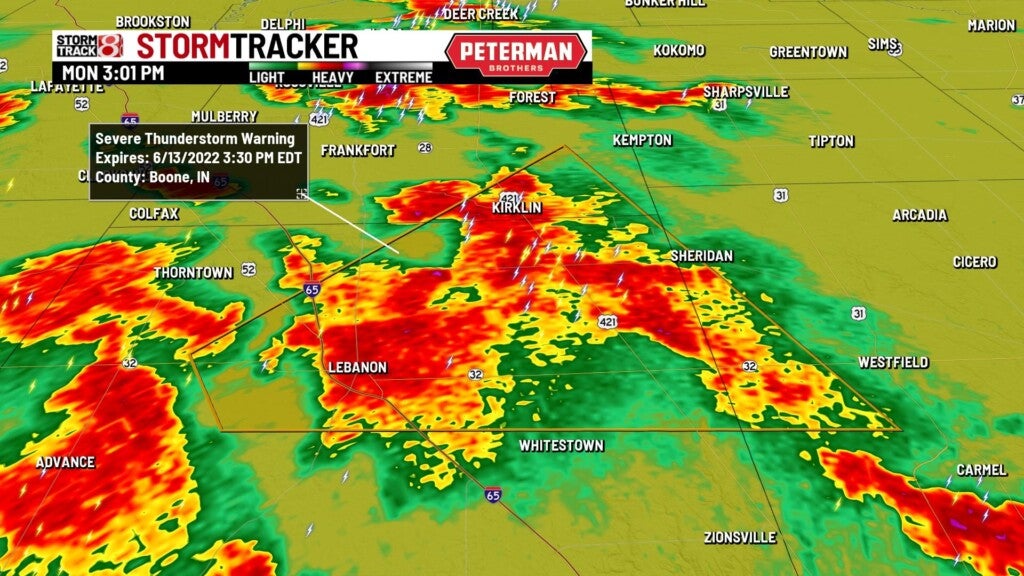
A severe thunderstorm warning was issued until 3:30 p.m. Monday for Boone, Clinton and Hamilton counties.
The National Weather Service received reports of pea-sized hail around 86th and Meridian streets in Indianapolis.
2:27 p.m.
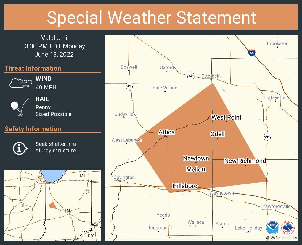
A special weather statement was issued for the communities of Attica, Williamsport and West Point until 3 p.m.
2:26 p.m.
Storm Track 8 meteorologist Ryan Morse display a video on Twitter and says, “Storms breaking the cap in western Indiana on satellite.”
2:22 p.m.
A severe thunderstorm warning is issued until 10 p.m. Monday for these counties: Adams, Bartholomew, Benton, Blackford, Boone, Brown, Carroll, Cass, Clark, Clay, Clinton, Dearborn, Decatur, Delaware, Fayette, Fountain, Franklin, Fulton, Grant, Greene, Hamilton, Hancock, Hendricks, Henry, Howard, Huntington, Jackson, Jasper, Jay, Jefferson, Jennings, Johnson, Lawrence, Madison, Marion, Miami
Monroe, Montgomery Morgan, Newton, Ohio, Owen, Parke, Pulaski, Putnam, Randolph, Ripley, Rush, Scott, Shelby, Switzerland, Tippecanoe tipton union
Vermillion, Vigo, Wabash, Warren, Washington, Wayne, Wells and White.

2:06 p.m.
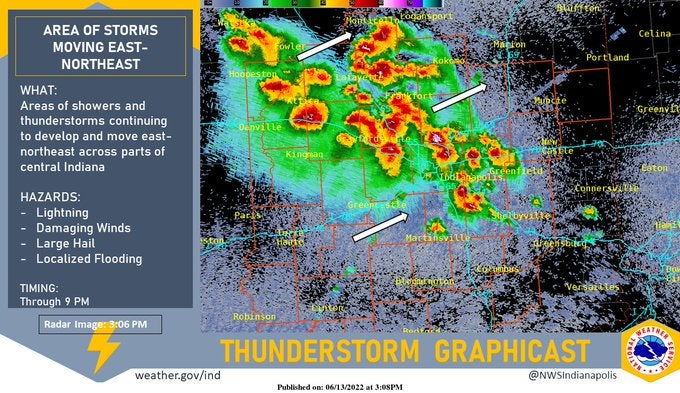
Storm Track 8 Chief Meteorologist Ashley Brown writes, “Showers and storms have started to develop over the last hour. There is a good chance that a severe thunderstorm watch is issued later this afternoon for central Indiana. Strong to severe storm threat remains with us until mainly sunset. Damaging wind/hail are the main threats.”
12:49 p.m.
South Bend Police Department says city community centers will be open for residents to cool off during the hot weather streak. Find locations and hours online.
12:43 p.m.
Evansville has opened a cooling center in the lobby of the CK Newsome Community Center. It’ll be open from 8 a.m.-5 p.m. until further notice.
11:56 a.m.
The Hendricks County Emergency Management Agency has announced these cooling stations: Guilford Township Public Library in Plainfield, the Danville Public Library, the Avon-Washington Township Public Library, and Northview Christian Church.
10:53 a.m.
When the temperature is 88 degrees or higher, the Gary, Indiana, emergency preparedness coordinator will open will activate a cooling center from 11 a.m. to 6 p.m. at the Ambridge Mann Pavilion, 2822 W. Fourth Ave. in Gary.