


Frigid temperatures settle in
INDIANAPOLIS (WISH) — Our first big shot of arctic air has moved into central Indiana.
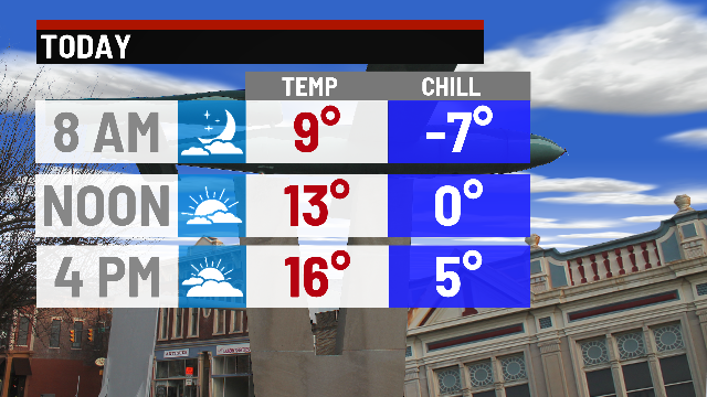
Today:
After our Saturday winter system, much colder air has moved in as advertised. With a strong north/northwest flow, expect some scattered lake effect snow showers to be aroud from time to time through the day. Not much in the way of accumulation, but we’re cold enough that anything falling will easitly stick, making roads a bit more slick.
Meanwhile, temperatuers will be the big story Sunday. We’ll hold into the middle teens for much of the day. With breezy winds, wind chills will likely be below 0° for a good poritons of the day.

Tonight:
Clear and conditions will go along with easily the coldest temperatures of the season thus far. Expect lows to fall below zero for most locations, and wind chills as low as -10° to -15°.
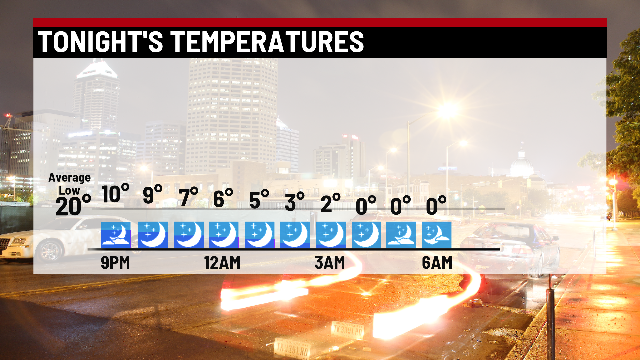

Wind chill advisories have already been placed for far eastern Indiana.

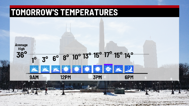
Monday:
Dry and cold day for the holida. Expect a mix of sun and clouds, with highs in the middle to upper teens.
8 day forecast:
A quick boost in temperatuers heading into Tuesday. Highs should jump to around 40°, before out next storm system brings mainly rain late Tuesday night, with a mixed bag of rain and snow on Wednesday. Another significant shot of cold air settles in starting Thursday, with a clipper moving in Saturday brining another potential for a quick, light accumulating snow to kick off the weekend.
