


December’s deadliest tornado outbreak revisited one year later

INDIANAPOLIS (WISH) – One year ago, the deadliest December tornado outbreak on record heavily impacted the lower Ohio and Mississippi valleys on Dec. 10th and 11th.
A lofty 71 tornadoes touched down with Kentucky, Arkansas, Tennessee, Missouri, and Illinois receiving the brunt of the action. Let’s break down why this outbreak became highly destructive and deadly on a scale not seen in years.
A volatile disturbance was set to roll into the region by Friday, Dec. 10th, and combining this with abundant moisture opened the floodgates to a widespread primed area of threatening weather. The upper level jet stream was highly potent with a screaming jet streak of winds over 100 MPH. This powerful belt of upper level wind aided in the strengthening of lower and mid-level flow. Plentiful moisture was able to traverse northward due to the winds being in a stronger state overall.


By Friday morning, much of the Mississippi and lower Ohio valleys sat in an Enhanced Risk (level 3/5) of severe weather. At the 11:30 AM EST risk update, the Storm Prediction Center upgraded to a Moderate Risk (level 4/5) in a concentrated area for the mid-Mississippi valley. Central Indiana would also be placed entirely in the Enhanced in the 11:30 AM update too. The risk for strong to violent tornadoes, significant wind gusts, and large hail were all increasing.


By sunset, tornado watches had begun to be issued from Arkansas up to Kentucky and Indiana. By 7 PM CST, tornadoes were being reported near Jonesboro, AR as a supercell was beginning to rapidly intensify. This supercell would become the most remembered from this outbreak for what it was about to do over the next six hours.
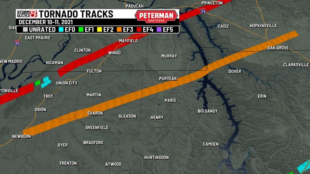
A violent tornado then formed just after 7 PM CST just east of Jonesboro and would tear through part of Monette and Leachville, AR. A nursing home in Monette was completely leveled. This fast moving large tornado continued to speed into the bootheel of Missouri near Caruthersville. The tornado then hit Samburg, TN head on before dissipating. Three weak tornadoes were spawned just west of Union City, TN before the deadliest and longest tracked tracked tornado of this event took place.

At 8:49 PM CST, another violent tornado began near Woodland Mills, TN. This tornado raced through and devastated Cayce and close to Crutchfield, KY. The worst was yet to come as by 9:30 PM CST, this enormous tornado was on a collision course with Mayfield, KY. Mayfield would end up being completely leveled with 20 people being killed in the city, and eight of the fatalities in the city itself occurred at the candle factory. Other communities such as Benton, Dawson Springs, and Bremen would be completely destroyed. The UK research facility plant was also decimated.


A satellite tornado would briefly accompany the western Kentucky tornado near Central City. This highly destructive violent tornado finally dissipated at 11:47 PM CST south of Hardinsburg, KY.
While the Kentucky supercell was on a warpath, other dangerous tornadoes were observed near St. Louis, MO and Edwardsville, IL. Near Edwardsville, an amazon facility suffered a partial collapse with six people being killed in there. Additional strong tornadoes would take place near Ramsey, Virginia, Atterbery, Mattoon, and Chrisman, IL.


A second long tracked supercell would get going and produce a family of intense tornadoes beginning with a long lived EF3 from Newbern, TN to near Hopkinsville, KY. This tornado stayed on the ground for 122 miles and was up to 1.14 miles wide. Thankfully, nobody was killed in this tornado, but subsequent tornadoes that were spawned from this cell became deadly.
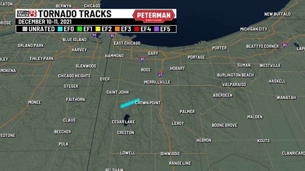
Indiana was thankfully spared from the ferocious tornado activity, but there was one weak tornado that was spawned in Crown Point just after 11 PM EST.
A cluster of powerful tornadoes would form in between 12:45 AM CST and 1:40 AM CST near Russellville and through Bowling Green. Sixteen people were killed in Bowling Green by a borderline violent tornado that tracked very close to Western Kentucky University. Three additional significant tornadoes would take place through Cave City, Summerville, and near Samola, KY.

Another cluster of tornadic activity would ensue from Lexington, TN to northeast of Nashville, TN in between 1:30 AM CST and 4:30 AM CST.

By daybreak of Dec. 11th, many photos and videos surfaced of complete devastation and changed communities. The sad reality that was immediately realized was that thousands of people were not going to have the same Christmas that they wanted to. The resiliency, however, that was shown in the days and months after the outbreak was tremendous. Here are stats on some of the most noticeable tornadoes from this prolific event:

- Monette, AR – EF4: 81.17 mile path; 0.99 mile width (8 deaths)
- Outer St. Louis – EF3: 24,77 mile path; 0.09 mile width (1 death)
- Newbern, TN – EF3: 122.91 mile path; 1.14 mile width
- Bowling Green, KY – EF3: 29.26 mile path; 0.25 mile width (16 deaths)
- Saloma, KY- EF3: 14.54 mile path; 0.25 mile width (1 death)
Initial thoughts of the violent supercell that tracked through Arkansas, Missouri, Tennessee, and Kentucky were that one tornado possibly tracked up to 250 miles. This cell has been referenced as the “Quad State supercell”. In all, 89 people were unfortunately killed with 74 of those deaths occurring in Kentucky alone. This even surpassed the Vicksburg, MS F5 from December 1953 as the deadliest December tornado event in our nation’s history. It was also the largest December tornado outbreak on record until it was surpassed five days later from an even larger outbreak that produced 120 tornadoes.

Severe weather can occur at any time of the year, and we must always be ready for inclement weather if the setup calls for the potential of it.