


May 2003 tornado outbreak remembered 20 years later

INDIANAPOLIS (WISH) – A prolonged and destructive tornado outbreak sequence occurred across much of the Great Plains and eastern United States within the first half of May 2003.
This extensive event featured 363 tornadoes from May 3-11 with 62 of those tornadoes being rated F2 or higher (significant to violent). It led way to May 2003 as a whole being the most active month for tornadoes of all-time (542) until it was surpassed by April 2011 with 773.
The May 2003 tornado outbreak killed 42 people and injured more than 600 others. Since, there were multiple days with exceptional tornado activity, let’s break down those days individually.
Sunday, May 4: The most active day of the entire event stemmed from an unseasonably strong low pressure system that sat over northeastern Kansas. This low pressure system had a potent warm front, cold front, and dryline. A system like this is conducive to major tornado outbreaks when it is in association with a volatile mid-level trough and robust upper level jet stream.
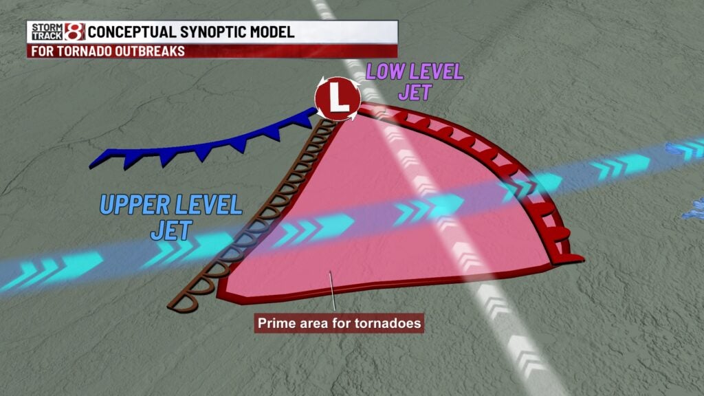
That example in the previous system played out on May 4 when 79 tornadoes wreaked havoc mainly across eastern Kansas, Missouri, Arkansas, and Tennessee. Four of the tornadoes attained F4 intensity.
The Storm Prediction Center would issue a high risk of severe weather for parts of Arkansas, Kansas, Missouri, and Oklahoma with the potential for long-tracked violent tornadoes.
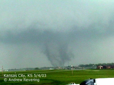
One of the areas hardest hit was northern portions of the Kansas City metropolitan area, and it was the region’s most significant outbreak since 1977. Five tornadoes occurred in the aforementioned area with two of those reaching F4 strength in northern Kansas City, KS and Gladstone, MO respectively.

Meanwhile, over 100 miles south of Kansas City, more intense supercells fired off in southeastern Kansas into southwestern Missouri. At 4:32 PM CDT, a destructive F4 tornado touched down in Neosho county, Kansas and would tear a 33-mile path of heavy damage through/near Girard and Franklin, KS. This tornado was debated to have potentially caused F5 damage in Franklin.

Things went downhill very quickly for southwestern Missouri as a series of strong tornadoes tore through the region. Here are some of the notable tornadoes from this sequence of events:
- Liberal-Urbana, MO – F3, 86 mile path (5 deaths)
- Melrose, KS to Carl Junction, MO – F3, 25 mile path (5 deaths)
- Pierce City, MO – F3, 49 mile path (7 deaths)
- Camdenton, MO – F3, 14 mile path (4 deaths)


The Liberal, MO tornado was the longest tracked tornado of the entire outbreak. In Pierce City, MO, major damage was present in town along with the National Guard Amory that was filled with people taking shelter.

Another violent F4 tornado would go on to cause havoc in southern Jackson and Lexington, TN with 11 people being killed. In total, 38 people died on May 4, which was 90% of the entire tornado outbreak death toll. This system would prompt another high risk on May 5 with 28 tornadoes taking place in mainly Tennessee and Mississippi.
Tuesday, May 6: A new low pressure system formed just east of the Rockies on May 5 and tracked into Missouri by the evening of May 6. This system would generate another big round of tornadic activity with 75 tornadoes touching down. Portions of the southeastern U.S. and mid-Mississippi valley would encounter the brunt of the activity.
The most notable tornado on May 6 was a large F4 that tracked for 33 miles after sunset from New Grand Chain to Golconda in far southern Illinois. Peak winds with this tornado were up to 210 MPH with two deaths occurring.

Thursday, May 8: A volatile weather pattern was taking shape once again in the plains by May 8, and this pattern resembled the one back on May 4. This time, the focus was mostly on Oklahoma and Kansas.
Forty-five tornadoes would transpire in states such as Kansas, Oklahoma, Colorado, Nebraska, Missouri, Tennessee, Illinois, Indiana, and Virginia. Moore, Oklahoma, a city just hit by a highly violent F5 in May 1999, would see the strongest tornado of the day.
The Moore tornado on this day was a shorter lived F4 that tracked for 17 miles. Some of the worst damage occurred at the General Motors Oklahoma City Assembly and the manufacturing plant near I-240.


Kansas also saw a couple of intense tornadoes on May 8 with the following:
- Osage City-Overbrook, KS – F3: 25 mile path
- Yates Center, KS – F3: 23 mile path
Friday, May 9: The active weather pattern carried on into May 9 with 29 more tornadoes being spawned. Virginia and North Carolina saw over a dozen weak tornadoes (F0 and F1). Central Oklahoma also saw more action including a large nighttime F3 that impacted northeastern Oklahoma City.

Saturday, May 10: The final extensive day of this mammoth outbreak showcased 49 tornadoes across mainly Illinois, Iowa, and Missouri.
Overall, this outbreak became the costliest on record of the 2000s. Here was the overall tornado, death, and injury count from the May 2003 tornado outbreak:
