


1993 Storm of the Century: a historic system revisited 30 years later
INDIANAPOLIS (WISH) – A three day span from Mar. 12-14, 1993 showcased one of the United States’ most impactful and historic cyclonic storm systems on record.
The remarkable aspects and widespread geographical extent of this system will always stand out more than most other cyclonic storms. The large spatial area of extreme weather conditions that took place is why many refer to this system as Storm of the Century, Superstorm, and/or The Blizzard of 1993. This is also sometimes called “no-name storm of 1993”.
During Mar. 11-12, 1993, temperatures across a majority of the eastern United States began to drop due to expansive areas of high pressure over the midwest and great plains. While the eastern U.S. was becoming colder, an area of low pressure formed over Mexico with a stationary front draped from west to east.
Eventually, a strong split-polar jet stream and mid-level disturbance would lead to the low pressure system rapidly deepening. The system’s central pressure fell to 991.0 millibars (mb) by 7 PM on Friday, Mar. 12. A powerful low-level jet over eastern Cuba and the Gulf of Mexico would enhance a cold front that extended from the low down to the Isthmus of Tehuantepec (Mexico).
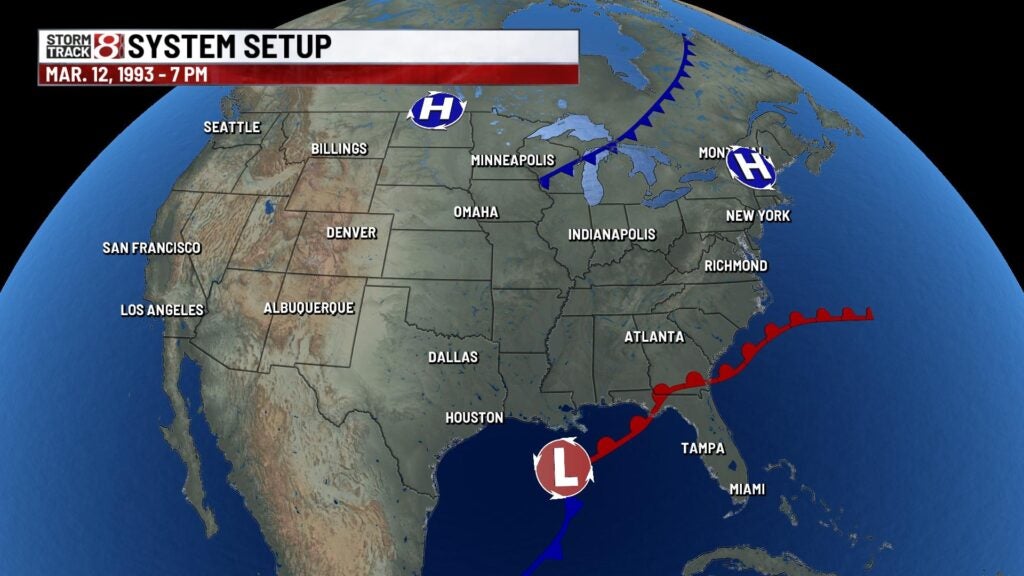
Once this system began to strengthen, everything would go downhill beginning on the night of Friday, Mar. 12. The powerful cold front was accelerating towards Florida in which a potent squall line had formed ahead of the front.
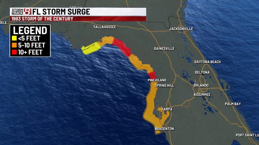
Areas along the western edge of Florida wound up dealing with a storm surge problem as wind gusts picked up substantially. Surge levels would end up being over ten feet in locations such as Pine Island, Steinhatchee, Delde and Keaton Beach. Many helicopter rescues had to take by early Saturday, Mar. 13, due to rising waters.
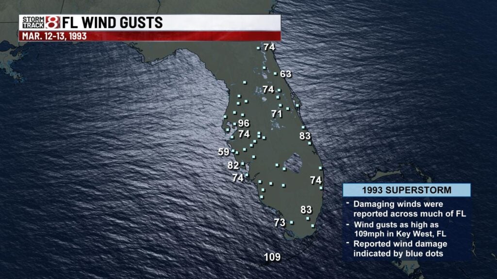
The aforementioned squall line would overall wreak havoc through most of Florida during the very early morning hours of Saturday, Mar. 13 with wind gusts pushing over 100 MPH. These ferocious winds would down many trees statewide. Along with the high winds, embedded supercells in the line produced 11 tornadoes.


Unfortunately, a total of 44 people lost their lives in Florida.
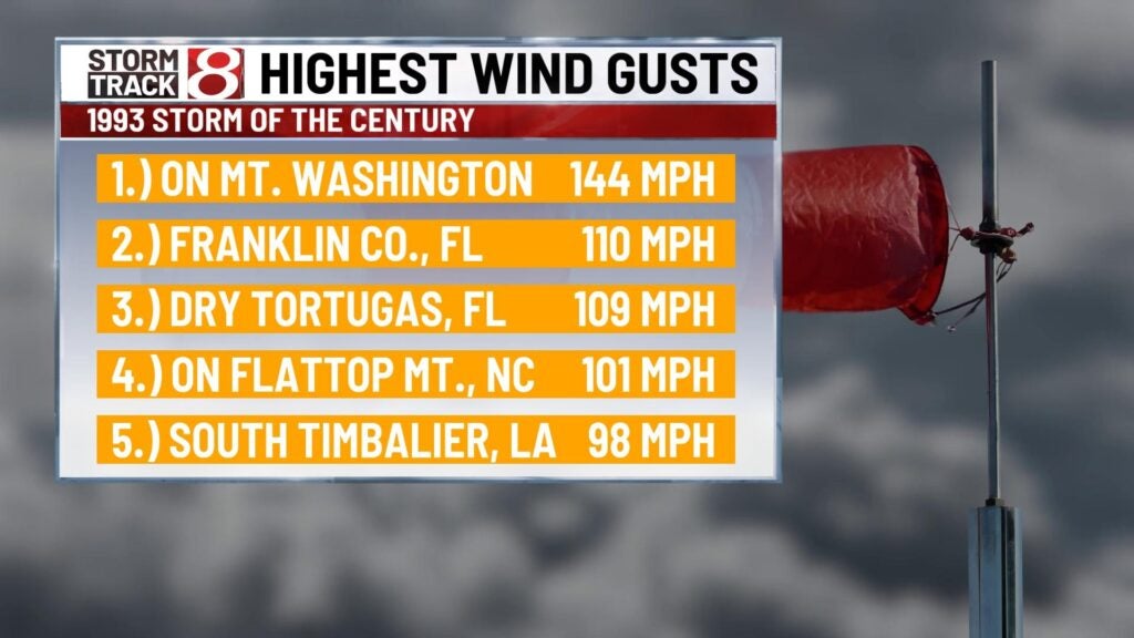
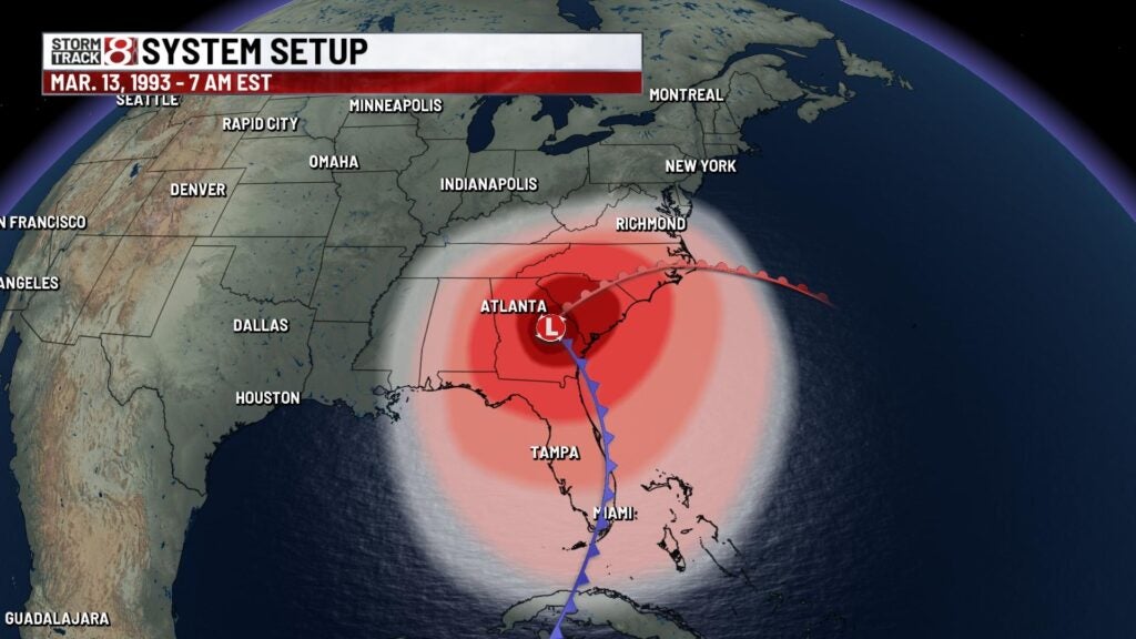
The powerful system would then trek into the southeastern U.S. by the morning of Mar. 13. This is when a massive stretch of heavy snow and blizzard conditions formed from Alabama and Georgia and eventually up through the Carolinas, Virginia, and the northeast. The cold air that was already in place in the eastern U.S. helped lead way to these conditions as the system moved in. There was even some thundersnow from Georgia to Pennsylvania. Wind gusts up to 80-90 MPH were also observed in the northeast.
Due to the system pulling in colder air behind it, areas as far south as Jacksonville, FL saw flurries with portions of central Florida getting a trace of snow. The snow overall caught many people off guard in the southeast.
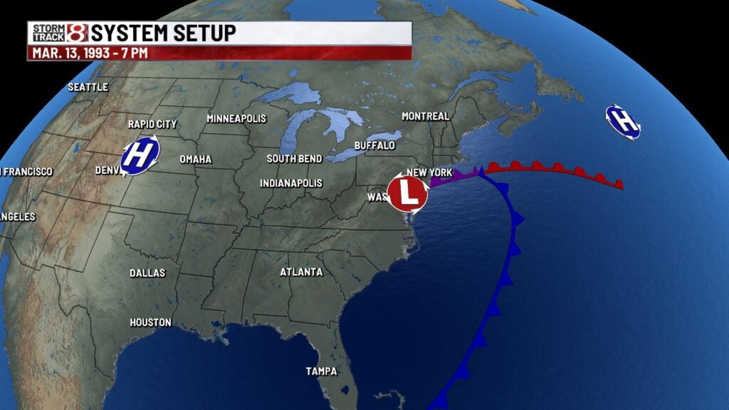
Hundreds of people had to be rescued from the Appalachians due to lofty amounts of snow and snow drifts well over ten feet. Mount Mitchell in North Carolina even had 14 foot snow drifts at one point. All airports along the eastern seaboard were closed due to the extreme winds and snow. The weight of the snowfalls collapsed several factory roofs in the south. As a whole, at least 26 states and much of eastern Canada were impacted by the Storm of the Century in some way, shape, or form.
Vessels at seas were not spared either by this mammoth event. In the North Atlantic region, the Gold Bond Conveyor ship that was en route from Halifax, Nova Scotia to Tampa, Florida was unfortunately lost at sea. roughly 60 miles southeast of Sable Island, Nova Scotia. All 33 crew on board perished. Ironically, this ship survived the Perfect Storm of 1991.
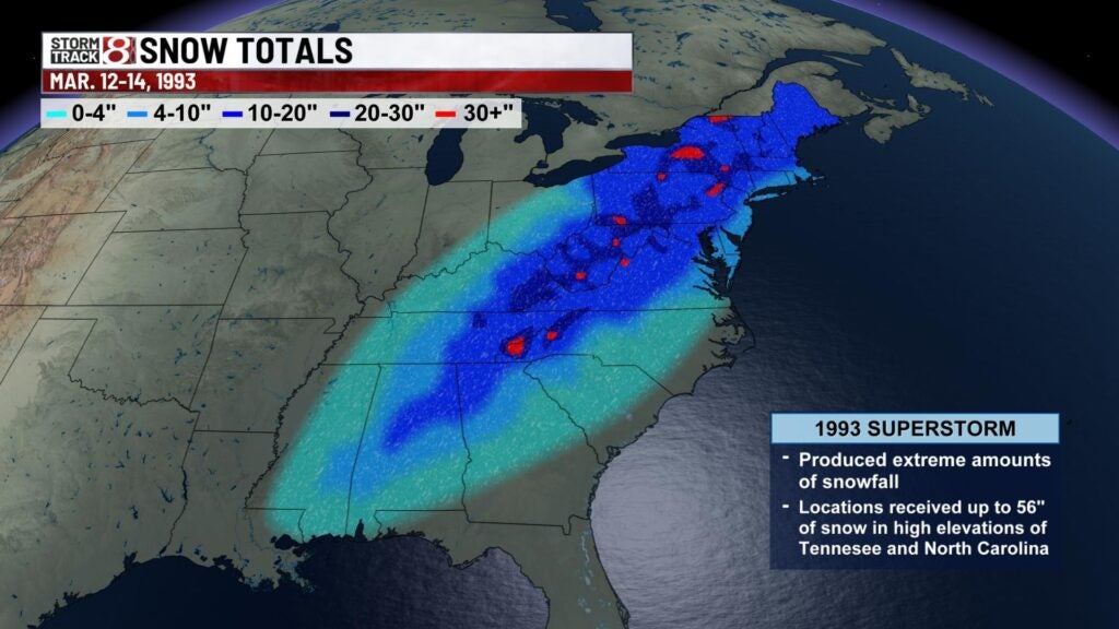
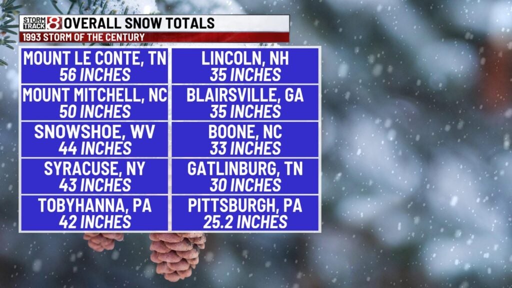
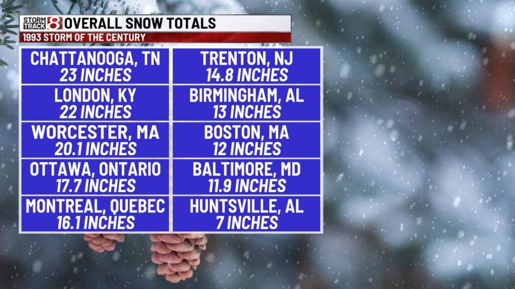
One stunning result of this system to break down further was the widespread extent of significant snowfall that stretched from the northeast down to as far south as southern Alabama. Mount Le Conte in Sevier county, TN picked up the most snow of this event with 56 inches. Birmingham, AL for instance had record breaking snowfall with 13 inches.
Over 200 people died as a result of this powerful cyclonic storm system. Up to 118 of those fatalities occurred during the post-storm aftermath and cleanup. Record low March sea-level pressures were also recorded in 12 states along the eastern seaboard. The lowest pressure this system attained was 960 mb in the New England region.
Storm of the Century marked a milestone in weather forecasting of the United States. By Mar. 8, 1993, several operational numerical weather prediction models and medium-range forecasters at the National Weather Service recognized the threat of a significant snowstorm. This marked the first time National Weather Service meteorologists were able to predict accurately a system’s severity five days in advance.
Official blizzard warnings were issued two days before the storm arrived once shorter-range models began to confirm the predictions. Forecasters were finally confident enough of the computer-forecast models to support decisions by several northeastern states to declare a state of emergency even before the snow started to fall.