


Storm Track 8 blog: Storm watches south of Indianapolis
INDIANAPOLIS (WISH) — Severe thunderstorm watches has been issued for parts of Illinois, Indiana, Kentucky and Ohio until 11 p.m. EDT Monday.
By 11 p.m. EDT Monday, only these counties in southern Indiana remained under a severe thunderstorm watch until midnight CDT/1 a.m. EDT: Gibson, Pike, Posey, Spencer, Vanderburgh and Warrick.
- Storm Track 8 interactive radar | Get the WISH-TV weather app for iOS devices | Get the WISH-TV weather app for Android devices
Initially, these counties in Indiana were part of the watches issued Monday afternoon through 11 p.m. EDT: Bartholomew, Brown, Clark, Crawford, Daviess, Dearborn, Decatur, Dubois, Floyd, Franklin, Gibson, Greene, Harrison, Jackson, Jefferson, Jennings, Knox, Lawrence, Martin, Monroe, Ohio, Orange, Perry, Pike, Posey, Ripley, Scott, Spencer, Sullivan, Switzerland, Vanderburgh, Warrick and Washington.
At 9:42 p.m., these Indiana counties were removed from the watch: Dearborn, Franklin, Ohio, Ripley and Switzerland.
At 9:55 p.m., these Indiana counties were removed from the watch: Bartholomew, Brown, Decatur, Jackson, Jennings, Lawrence and Monroe.
At 10:52 p.m., these Indiana counties were removed from the watch: Daviess, Greene, Knox, Martin and Sullivan.
The National Weather Service Storm Prediction Center says primary threats including scattered, damaging winds with isolated gusts up to 75 mph; isolated hail up to 1.5 inches in diameter possible; and a tornado or two.
Storm Track 8 Chief Meteorologist Ashley Brown said on News 8 at 5 p.m. that she did not expect the watch to last through 11 p.m.
A Severe Thunderstorm Watch means conditions are favorable for severe thunderstorms in and close to the watch area.
10:52 p.m.
A new severe thunderstorm watch was issued until these counties in southern Indiana until midnight CDT/1 a.m. EDT: Gibson, Pike, Posey, Spencer, Vanderburgh and Warrick.
10:40 p.m.
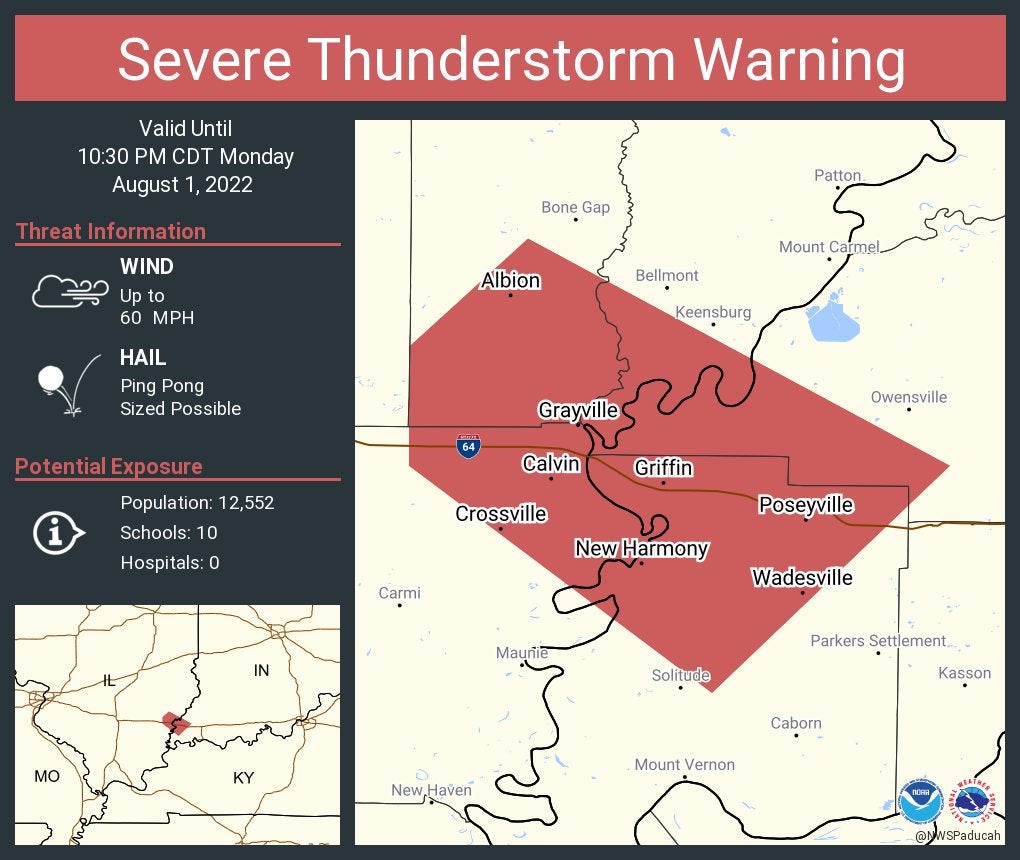
Severe Thunderstorm Warning including Albion IL, Grayville IL and Poseyville IN until 10:30 PM CDT
10:01 p.m.
A strong thunderstorm will impact portions of southwestern Vanderburgh and east central Posey counties in Indiana and central Henderson County in Kentucky through 9:45 p.m. CDT Monday. At 9 p.m. CDT, Doppler radar was tracking a strong thunderstorm 9 miles east of Mount Vernon, moving southeast at 25 mph. Primary hazards were winds in excess of 40 mph and nickel-sized hail.
9:45 p.m.
AES Indiana tweet: “969 customers remain without power following Monday morning’s damaging winds and thunderstorms. Our crews and contractors will continue to work safely throughout the night on storm restoration efforts. We thank you for your patience.”
9:13 p.m.
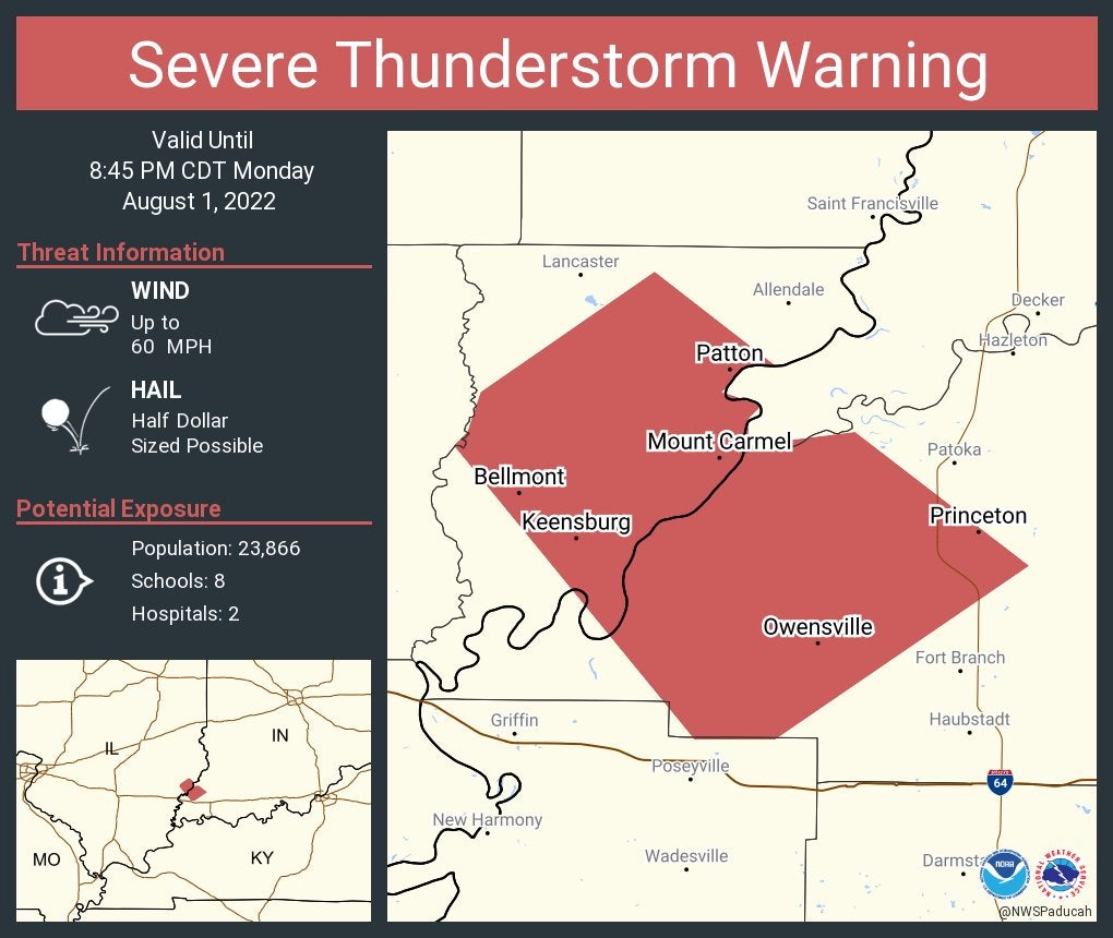
Severe Thunderstorm Warning continues for Princeton IN, Mount Carmel IL and Owensville IN until 8:45 PM CDT
8:45 p.m.
A special weather statement has been issued for Evansville IN, Parkers Settlement IN and Caborn IN until 8:15 PM CDT

8:11 p.m.
Severe Thunderstorm Warning including Evansville IN, Owensboro KY and Newburgh IN until 8:00 PM CDT. This storm will contain wind gusts to 70 MPH!

7:58 p.m.
The National Weather Service at Indianapolis tweets: Strong to severe storms will move southeast around 25 mph across the southwest half of Knox County the next few hours. Torrential rainfall, flooding, large hail, damaging winds, frequent cloud-to-ground lightning. Isolated tornado possible.

7:56 p.m.
Severe Thunderstorm Warning including Decker IN and Beal IN until 8:30 PM EDT

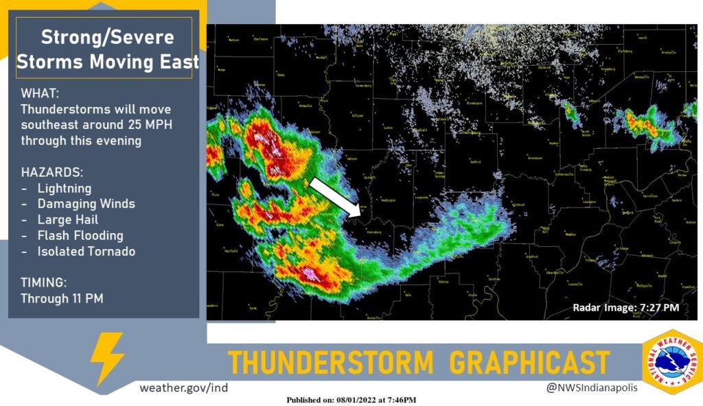
7:46 p.m.
The National Weather Service at Indianapolis tweets: Strong to severe thunderstorms will move southeast over the southwestern half of Knox County next few hours. Torrential rainfall, large hail, damaging winds, frequent cloud-to-ground lightning and flooding possible. An isolated tornado will also be possible.
7:45 p.m.
Severe Thunderstorm Warning including Evansville IN, Highland IN and Melody Hill IN until 7:30 PM CDT

7:26 p.m.
Severe Thunderstorm Warning including Fort Branch IN, Haubstadt IN and Owensville IN until 7:00 PM CDT

7:06 p.m.
Wind gust of 68 mph reported a few minutes ago at the Evansville airport with severe thunderstorms, according to the weather service at Paducah, Kentucky.
6:59 p.m.
From the weather service in Wilmington, Ohio: The tornado warning in Dearborn, Indiana, was allowed to expire as rotation weakened. Several of these storms near the Ohio River have exhibited rotation, so we continue to closely monitor the threat for a brief tornado.
6:53 p.m.
Severe Thunderstorm Warning including Princeton, Fort Branch and Oakland City, Indiana, until 6:30 p.m. CDT.

6:52 p.m.
A special weather statement has been issued for Martin County, Indiana, until 7:15 p.m. EDT.

6:32 p.m.
Severe Thunderstorm Warning including Decker IN and Beal IN until 7:00 PM EDT

6:29 p.m.
Tornado Warning continues for Bright IN, Hidden Valley IN and Lawrenceburg IN until 6:45 PM EDT

6:10 p.m.
The National Weather Service at Indianapolis says straight-line winds and a Gustnado happened near Anderson around 9:28 a.m. Monday.
A line of strong thunderstorms moving eastward produced straight-line winds from 60 to 70 mph along with a brief gustnado on the leading edge of the gust front, otherwise known as an outflow boundary. The gustnado was observed by a witness who was it form over Aqua Gardens Lake on the leading edge of the thunderstorm. The feature then moved onto land in a northeast direction for approximately 1 mile. Straight-line winds also produced damage to the east. A few trees were downed and larger branches were broken from both the straight line winds and the circulation associated with the gustnado. A few boards on a pier were lifted as well.
5:11 p.m.
A special weather statement was issued for parts of Jefferson County in southern Indiana.

4:59 p.m.
A Severe Thunderstorm Watch was issued for parts of Ohio and Indiana until 11 p.m. EDT. These counties in Indiana are part of the watch: Dearborn, Franklin, Ohio, Ripley and Switzerland.
3:40 p.m.
A Severe Thunderstorm Watch was issued for parts of Illinois, Indiana and Kentucky until 11 p.m. EDT. These counties in Indiana are part of the watch: Bartholomew, Brown, Clark, Crawford, Daviess, Decatur, Dubois, Floyd, Gibson, Greene, Harrison, Jackson, Jefferson, Jennings, Knox, Lawrence, Martin, Monroe, Orange, Perry, Pike, Posey, Scott, Spencer, Sullivan, Vanderburgh, Warrick and Washington.
1:30 p.m.
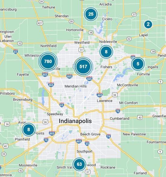
At 1:30 p.m., just under 4,000 AES Indiana customers are without power.
Check the AES Indiana outages map to find out when power in your area will be restored.
AES says crews are working to restore power.
Report a power outage at 317-261-8111.

As of 1:30 p.m., about 1,000 Duke Energy customers are without power in the Indianapolis area.
This includes nearly 480 people northwest of Zionsville and about 400 people in Carmel.
Duke says crews are working to restore power.
Report a power outage by calling 800-343-3525 or by visiting the Duke Energy website.

12:45 p.m.
As of 12:45 p.m., more than 5,400 AES Indiana customers are without power.
Check the AES Indiana outages map to find out when power in your area will be restored.
AES says crews are working to restore power.
Report a power outage at 317-261-8111.
As of 12:45 p.m., there are about 1,300 Duke Energy customers without power around the Indianapolis metro area.
This includes nearly 800 people south of Zionsville and about 400 people in Carmel.
Duke says crews are working to restore power.
Report a power outage by calling 800-343-3525 or by visiting the Duke Energy website.
11:30 a.m.
As of 11:30 a.m., more than 6,400 AES Indiana customers are without power.
This includes more than 1,100 people near Eagle Creek Park and more than 600 people near Castleton.
AES Indiana did not say when power will be restored.
Report a power outage at 317-261-8111.
As of 11:30 a.m., there were about 3,000 Duke Energy customers without power near Indianapolis.
This includes about 2,000 people in Carmel.
Duke did not say when power will be restored.
Report a power outage by calling 800-343-3525 or by visiting the Duke Energy website.

At least one home along Jordan Road in Carmel was damaged when severe weather caused a tree to fall on the roof.

10:05 a.m.
As of 10:05 a.m., at least 9,600 AES Indiana customers are without power.
This includes more than 2,000 people along Southport Road just northwest of Acton Park.
AES Indiana did not say when power will be restored.
Report a power outage at 317-261-8111.

As of 10:10 a.m., there are at least 3,000 Duke Energy customers without power in the Indy area.
This includes about 2,000 people in Carmel.
Duke did not say when power will be restored.
Report a power outage by calling 800-343-3525 or by visiting the Duke Energy website.
9:42 a.m.
A Severe Thunderstorm Warning is in effect for the following locations until 10:45 a.m.:
- Franklin County
- Wayne County
- Union County
- Fayette County
At 9:41 a.m., severe thunderstorms were located along a line extending from Shelbyville to New Castle, moving east at 45 mph.
Hazards include 60 mph wind gusts. Damage to trees and power lines is expected.
Locations impacted include: Richmond, Connersville, Batesville, Brookville, Centerville, Cambridge City, Liberty, Hagerstown, Fountain City, Dublin, West College Corner, Oldenburg, Lake Santee, Franklin, Salem, Waterloo, Blooming Grove, Columbia, Metamora, and Bunker Hill.
This includes Interstate 70 between mile markers 134 and 156 and Interstate 74 between mile markers 145 and 148.
9:25 a.m.
A Severe Thunderstorm Warning is in place until 10 a.m. for the following counties:
- East central Madison County
- Southern Delaware County
- Southwestern Randolph County
- Northern Henry County
At 9:25 a.m., a severe thunderstorm was located over Anderson, moving east at 60 mph.
Hazards include 70 mph wind gusts. Expect considerable tree damage. Damage is likely to mobile homes, roofs, and outbuildings.
Areas included in the warning are Daleville, Yorktown, Springport, Summit Lake State Park, and Prairie Creek Reservoir.
Other locations in the path of this severe thunderstorm include Mooreland, Blountsville, and Interstate 69 between mile markers 226 and 243.
9:14 a.m.
A Severe Thunderstorm Warning has been issued until 10 a.m. for the following counties:
- Southern Madison County
- Shelby County
- Hancock County
- Rush County
- Northern Decatur County
- Northeastern Johnson County
- Henry County
- Eastern Marion County
- Southeastern Hamilton County
At 9:14 a.m., severe thunderstorms were located along a line extending from seven miles southwest of Anderson to eight miles northwest of Shelbyville, moving east at 55 mph.
Hazards include 70 mph wind gusts. Expect considerable tree damage. Damage is likely to mobile homes, roofs, and outbuildings.
Severe thunderstorms will be near Shelbyville, Marklevill, Wilkinson, Shirley, Kennard, Cadiz, Manilla, and Waldron.
Other locations in the path of these severe thunderstorms include St. Paul, Spiceland, Sulphur Springs, Mount Summit, Greensboro, Moscow, New Castle, Lewisville, Milroy, Dunreith, Sandusky, Straughn, New Salem, Clarksburg, and Lake Santee.
Included in the warnings are:
- Interstate 65 between mile markers 91 and 98
- Interstate 69 between mile markers 210 and 226
- Interstate 70 between mile markers 94 and 133
- Interstate 74 between mile markers 99 and 131
- Interstate 74 between mile markers 133 and 138
- Interstate 74 between mile markers 143 and 144
9:05 a.m.
A Severe Thunderstorm Warning remains in effect until 9:15 a.m. for eastern Morgan County, Johnson County, Marion County, northwestern Brown County, eastern Hendricks County, and southeastern Boone and Hamilton Counties.
At 8:54 a.m., a severe thunderstorm was located over Carmel, moving east at 50 mph.
Hazards include 60 mph wind gusts and nickel size hail. Damage to roofs, siding, and trees is expected.
This severe storm will Fishers, Geist Reservoir, and Lawrence.
This includes Interstate 65 between mile markers 84 and 128, Interstate 69 between mile markers 200 and 211, Interstate 70 between mile markers 67 and 93, and Interstate 74 between mile markers 70 and 100.
8:45 a.m.
A Severe Thunderstorm Warning remains in effect until 9:15 a.m. for Morgan, Johnson, Marion, Boone, and Hamilton Counties as well as northwestern Brown and eastern Hendricks Counties.
At 8:44 a.m., a severe thunderstorm was located near Lebanon and moving east at 50 mph.
Hazards include 60 mph wind gusts and nickel size hail.
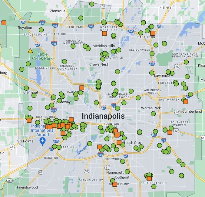
Locations in the path of this storm include Zionsville, Carmel, Westfield, Meridian Hills, Williams Creek, Noblesville, Castleton, Indianapolis, Fishers, Geist Reservoir, and Lawrence.
This includes Interstate 65 between mile markers 84 and 147, Interstate 69 between mile markers 200 and 211, Interstate 70 between mile markers 57 and 93, and Interstate 74 between mile markers 59 and 100.
8:35 a.m.
A Severe Thunderstorm Warning is in place until 9:15 a.m. for Boone, Hamilton, Johnson, Marion, and Morgan Counties, as well as northwestern Brown County and eastern Hendricks County.
At 8:34 a.m., a severe thunderstorm was located near Brownsburg, moving east at 60 mph.
Hazards include 60 mph wind gusts and nickel-size hail. Damage to roofs, sidings, and trees is expected.
Areas in the path of the storm include Avon, Plainfield, Speedway, Clermont, Eagle Creek Reservoir, Indianapolis International Airport, Meridian Hills, Rocky Ripple, Williams Creek, Wynnedale, Spring Hill, Crows Nest, and North Crows Nest.
Beech Grove, Monument Circle, the Indiana State Fairgrounds, Broad Ripple, Warren Park, and Cumberland will also be impacted.
This includes Interstate 65 between mile markers 84 and 147, Interstate 69 between mile markers 200 and 211, Interstate 70 between mile markers 57 and 93, and Interstate 74 between mile markers 59 and 100.
8:12 a.m.
A Severe Thunderstorm Warning is in place until 8:45 a.m. for northwestern Monroe County, western Morgan County, western Hendricks County, central Clay County, northern Owen County, southwestern Boone County, southeastern Montgomery County, and Putnam County.
At 8:12 a.m., a storm was located eight miles northeast of Brazil, moving at 45 mph.
Hazards include 60 mph wind gusts.
Areas in the path of the storm include Reelsville, Greencastle, Cloverdale, Cagles Mill Lake, Belle Union, Devore, Eminence, Quincy, Little Point, and Paragon.
The warning includes Interstate 70 between mile markers 17 and 19 and between mile markers 29 and 56. It also includes Interstate 74 between mile markers 34 and 58.
7:45 a.m.
The National Weather Service has issued a Severe Thunderstorm Warning for Parke County, Vermillion County, northwestern Clay County, and northeastern Vigo County until 8:30 a.m.
Severe thunderstorms were located extending from near Newport to several miles northeast of Vermillion. The storms were moving east at 50 mph.
Hazards include 60 mph wind gusts. Damage to roofs, siding, and trees is expected.
Large hail, damaging winds, and cloud-to-ground lightning is occurring with these storms. Torrential rainfall is occurring with these storms and may lead to flash flooding.
Locations in the path of the severe thunderstorms include Bloomington, Newport, Universal, Clinton, Fairview Park, Montezuma, Mecca, Rosedale, Shephardsville, North Terre Haute, Turkey Run State Park, Rockville, Marshal, and Fontanet. Other locations include Staunton, Judson, Bridgeton, Brazil, Knightsville, Harmony, Carbon, Cecil Harden Lake, and I-70 between mile markers 20 and 28.