


Storms moving in Sunday
INDIANAPOLIS (WISH) — Some much needed rain is heading to parts of central Indiana Sunday, but it could also come with the risk of severe storms.
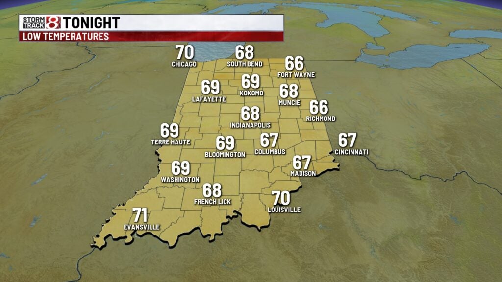
Saturday night:
We’ll see an increase in cloud cover through the late evening, as an approaching storm complex closes in on the state. Should stay dry until just before daybreak. Lows will be quite warm, only falling to the upper 60s/lower 70s.
Sunday:
Two waves of storms that we will be watching for the day on Sunday. The first will be the previoulsy mentioned complex that will be moving in from the west very early in the morning. This line should be weakening as it heads into the state, but some gusty winds could be possible, especially in western portions of the state. This first wave of storms should move out by no later than mid-morning.


Second wave has the higher chance of producing severe weather across the state. Look for development of storms along the U.S. 31 corridor by 2pm/3pm, and continue to build as the storms move southeast during the late afternoon. Window for severe weather will be 2pm – 8pm, with the higher probability for severe storms in eastern and southeastern parts of the state. Large hail, damaging wind, and even an isolated tornado can’t be ruled out.


Meanwhile, between the 2 waves of storms, it will become hot and humid, with highs surging close to 90°

Monday:
Much cooler and comfortable air settles in. Low pressure that brought storms the area Sunday will still be close enough to bring some scattered wrap around showers and storms. Highs top out in the mid/upper 70s.

8 day forecast:
Temperatures remain below average through Tuesday, before ramping up quickly by mid week. Storm chances return for late week into the weekend.
