May to start warm; more rain toward the end of the week
INDIANAPOLIS (WISH) — Central Indiana is closing out April in style.
Tuesday’s weather was excellent, with bright skies and much of the state reaching the 70s.
Expect an even warmer turn as we enter May on Wednesday, with highs pushing close to record territory. By the end of the week, expect more chances for rain and storms.
Tuesday night: A mostly clear and quiet night. Lows will dip down into the mid to upper 50s.


Wednesday: The start to May was shaping up to feel closer to summer. Temperatures will get back into the 80s under partly cloudy skies, with a slightly breezy wind as well. A couple of stray showers may happen in the morning and nighttime hours, but, overall, expect a mainly dry day.


Thursday: The warming trend will persist, challenging our warmest day of the year. Indy’s warmest day this year is 82 from April 15, and we may also break the record high for May 2, which is 87 from 1959. We can’t rule out isolated showers and storms in the afternoon and evening hours. Rain chances will increase as we get into early Friday morning.


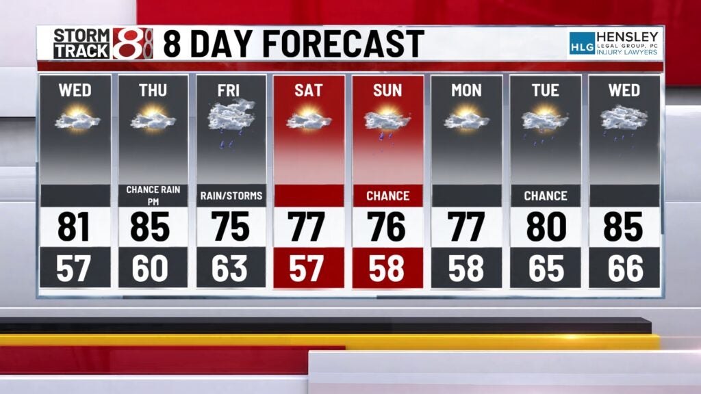
8-Day Forecast: We expect an active Friday with scattered showers and storms as highs fall back into the mid 70s. By Saturday morning for the 500 Festival Mini-Marathon in Indianapolis, we’re eyeing some dry time with temperatures in the upper 50s to start the event. A few more showers and storms may develop in the back half of Saturday into Sunday, with highs staying in the mid 70s. More 80s may be ahead early next week with continuing rain and storm chances.