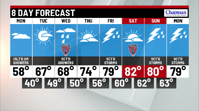
Cloudy and cool Monday

INDIANAPOLIS (WISH) — Temperatures remain 10°-15° degrees below average.
Today:
Upper level low responsible for cool and wet conditions on Sunday will continue to impact the region Monday. Expect clouds to hang tough for much of the day. A few isolated light showers will also be possible this morning.

Highs will run cool again today, topping out in the middle to upper 50s.

Tonight:
Drier air finally wins out late Monday afternoon into the evening. Skies will clear gradually through the evening. With cooler air in place and not much in the way of cloud cover, certainly possible for some patchy frost to develop overnight – especially for areas north of Indianapolis.


Tuesday:
Much better day on tap, as sunshine returns and temperatures respond. Highs top out in the middle 60s.

8 day forecast:
A nice warming trend is on tap this week. An upper-level wave will bring shower chances to the area Wednesday. Following that rain chance, expect highs to surge into the 70s and eventually 80s for late week into the weekend. Just slight chances for storms late Thursday night into Friday, and again on Sunday.