


Tropical Storm Elsa forms in Atlantic, could near Florida Peninsula
(CNN) — Tropical Storm Elsa is still several days from potentially nearing Florida — possibly around the site of the deadly condo collapse — as the third storm of the 2021 Atlantic hurricane season to threaten land in the United States.
“It is too soon to determine what, if any, impacts could occur there next week given the uncertainty in the long-range forecast,” the National Hurricane Center said.
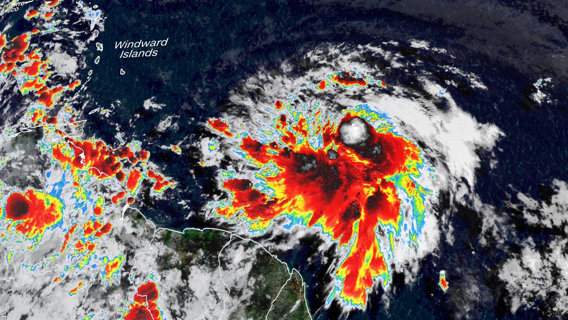
Elsa strengthened Thursday morning into a tropical storm with winds of 45 mph. At 5 p.m. ET, it was 410 miles east-southeast of the Windward Islands and racing west at 29 mph.
A tropical storm warning is in effect for Barbados and Martinique, St. Lucia, St. Vincent and the Grenadines. A tropical storm watch is in effect for Grenada and its dependencies, and for the southern and western coasts of Haiti from the southern border of the Dominican Republic to Le Mole le St. Nicholas.
Elsa, which is already spawning memes for the name it shares with Disney’s “Frozen” princess, will pass Friday near or over portions of the Windward Islands, bringing gusty winds and up to 10 inches of rain. It will then head into the eastern Caribbean Sea and move Saturday near the southern coast of Hispaniola. By early Sunday, Elsa is forecast to be near portions of eastern Cuba.
While the storm will bring tropical storm-force winds and heavy rain to the islands Friday, the fast movement could limit the flood potential.
Those near the recently erupted La Soufriere volcano in St. Vincent and the Grenadines have an additional concern to worry about — heavy rain causing lahars.
“As the volcano erupted, it deposited vast amounts of ash on the island, much of it at higher elevations. Heavy rain will mix with the ash, creating a slurry that may cause significant mudslide-like damage — called a lahar,” said CNN meteorologist Chad Myers.
Puerto Rico is also expecting rainfall, with localized amounts of up to 5 inches Friday into Saturday.
After that, the hurricane center has low confidence in the forecast track. Some weather models predict Elsa turns and stays east of Florida, while others take it into the Gulf of Mexico, leaving the entire Florida Peninsula in the cone of error.
The Florida Keys and portions of the southern Florida Peninsula early next week face a risk of storm surge, wind and rainfall impacts, the hurricane center warns.
How strong Elsa will be next week is also highly uncertain due to the possibility of land interaction and disagreements among the weather models. The hurricane center forecast now is on the low end for intensity, keeping Elsa as a tropical storm when it nears the Florida Peninsula.
Elsa won’t impact weekend condo search, governor says
Elsa is not expected to impact search and rescue efforts this weekend at the site of the condo collapse in Surfside, Florida, Gov. Ron DeSantis said Thursday.
“We are not expecting any impacts through Saturday,” he said. “But obviously, our meteorological team is actively monitoring the storm and will continue to provide any updates,” he said, adding the state Department of Emergency Management is working on contingency plans in case of storm effects.
State officials expect Elsa to turn northwest near South Florida by Monday, he said.
The Florida State Response Team has coordinated 500 on-scene local and state responders, DeSantis added. Search and rescue work at the site was temporarily halted Thursday because of structural concerns about the standing structure, the Miami-Dade County mayor said. It resumed in the evening.
Early-season formation in Atlantic’s Main Development Region
What makes Elsa unique is when and where its activity is developing.
As the calendar turned from June to July, climatology indicates a significant increase in tropical formation across the Atlantic Ocean’s Main Development Region (MDR).
It is however, unusual to see activity within this region this early in the hurricane season.
The MDR is roughly encompassed by the waters off west Africa through the Caribbean to Central America. It historically experiences an uptick in tropical activity between July and September because of warmer ocean waters, relaxing vertical wind shear and weaker trade winds.
These are all contributing factors to what the National Hurricane Center believes will be another above-average hurricane season.
Above-average season off to weak start
Even though the 2021 Atlantic hurricane season has amassed four named storms, they have been short-lived and relatively weak.
One way meteorologists quantify how active or inactive a hurricane season has been is by tracking the Accumulated Cyclone Energy (ACE). ACE is a parameter that takes the overall seasonal activity (to date) and combines “intensity and duration of Atlantic named storms and hurricanes,” according to the Climate Prediction Center.
So far this season, the ACE index stands at 3.3, with a mere 5.25 named storm days. If Elsa progresses as predicted, it will begin a steady march toward the forecast above-average season.