


Quiet Monday ahead; rain returns Tuesday
INDIANAPOLIS (WISH) — Temperatures warm closer to average for much of the work week.
This morning:
A frost advisory remains in effect until 10:00 a.m. for most of the state. Clear skies have allowed for temperatures to fall pretty quickly. As we approach daybreak, numbers should slip into the low to mid-30s across much of central Indiana.

Monday:
Expect lots of sunshine for the morning hours and a few clouds to build this afternoon. Temperatures should be warmer than what we experienced over the weekend, with highs back to the low to mid-60s across central Indiana.


Monday night:
Clouds will continue to increase tonight, and with warmer air flow, our temperatures should stay above any freezing-level threats. Overnight lows fall to the mid and upper 40s.

Tuesday:
A cold front marching through the state on Tuesday will bring a scattered shower and thunderstorm threat to much of the state, especially in the afternoon hours. Rainfall amounts range around 1/2 an inch or less.


High temperatures will hover around 60°.


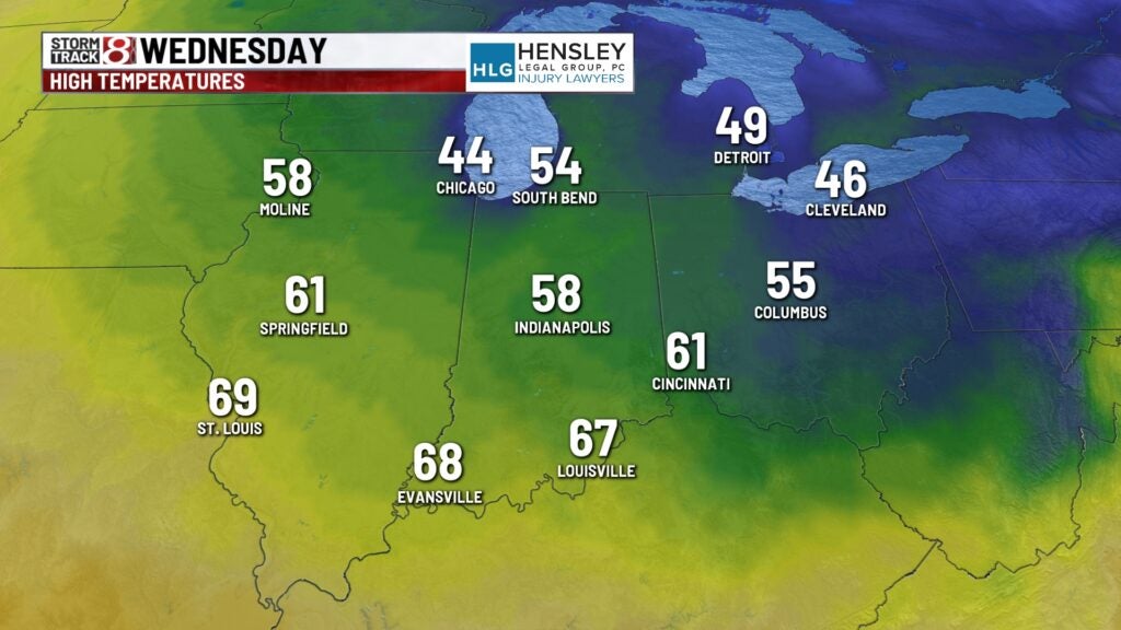
Wednesday:
The cooler temperatures behind the cold front will move in on Wednesday. High temperatures only hit the mid and upper 50s for the afternoon. There is potential for some patchy frost Wednesday night into Thursday morning in the eastern and north-central portions of the state.
8 day forecast:
Wet conditions and warmer temperatures are on the way. An active storm track will bring thunderstorm chances starting Friday and better chances coming in for Saturday and into Sunday as well.

Get updates for free with our Storm Track 8 Weather App and updates 24 hours a day on our weather page.