Super Tuesday tornado outbreak of 2008: 15 years later
INDIANAPOLIS (WISH) — It’s been 15 years since the deadly Super Tuesday tornado outbreak across the mid-South.
“Super Tuesday” is a reference to multiple states that were holding presidential primaries on Feb. 5, 2008.
A deep and vigorous trough was pushing in from the southwestern United States on Feb. 4. In tandem with the trough, there was a stout low pressure system that intensified over northern New Mexico and into northern Texas. This low would eventually slide northeastward into the Ozark mountains on Feb.5.
As the low progressed to the northeast, a potent upper level jet streak positioned itself over a well developed warm sector that included the Ozarks, lower Mississippi, Ohio and Tennessee valleys. This strong jet streak amplified the low and mid-level wind flow, and there was favorable turning of those winds. As a result, there was adequate wind shear for supercell development.
The combination of potent wind shear and instability from high levels of moisture yielded a very concerning risk of intense and long track tornadoes.
On February 5, a very warm and moist air mass was in place for most of the south. For this February day, temperatures soared into the 70s with dew points in the 60s. The first tornadoes formed late Tuesday afternoon. By 4 p.m. EST, the Storm Prediction Center had a high risk of severe weather in place from Arkansas up to far southern Illinois.

Around 4:50 p.m. CST, the longest track tornado of this outbreak began near Centerville, AR. This tornado quickly intensified as it went on to hit portions of or directly hit Atkins, Clinton, Mountain View, and Zion. One thing to note with this particular tornado was the menacing dark appearance it had during its life span while it was visible without needing lightning flashes to illuminate it.
This tornado would be rated EF4 and tore an extraordinary 122-mile path with 13 people being killed. It became the longest tracked tornado in Arkansas state history.
Tornadoes would then begin to break out further across parts of Tennessee, Mississippi, and Kentucky. Some of the notable tornadoes that would take place for the remainder of Feb. 5 were:
- Oxford, MS – EF3
- Stanton, TN – EF3 (3 deaths)
- Jackson, TN – EF4
- Savannah, TN – EF4 (3 deaths)
- Greenville, KY (3 deaths)
- Castalian Springs, TN (22 deaths)
The Jackson, TN EF4 went on to hit Union University with 12 students being trapped in buildings, but they were all thankfully rescued. Just after 9 p.m. CST, a supercell that spawned tornadoes over northern Mississippi, including the Savannah, TN EF4, moved northeast over Nashville, TN. Not long after the cell passed Nashville, the deadliest tornado of the entire outbreak would form just after 10 p.m. CST.
This tornado would devastate Castalian Springs and tear into Monroe and Cumberland counties in Kentucky at EF3 intensity. The Castalian Springs tornado would become the deadliest tornado to strike middle Tennessee in over 75 years.
The tornado warnings for this particular EF3 tornado caught our attention in that extra wording we’ve never seen used was utilized to convey the urgency of the situation. As tornado warnings were in effect for Monroe and Cumberland counties in Kentucky, the wording used in all-caps was: “Tompkinsville is in extreme danger.”
By the early morning hours of Feb. 6, additional intense to violent tornadoes took place at the following locations:
- Amos, KY – EF3 (4 deaths)
- Moulton, AL – EF4 (4 deaths)
- Pisgah, AL – EF4 (1 death)
The bulk of the tornadoes were in Tennessee and Kentucky. This storm system had multiple violent tornadoes within it. Overall, five EF4 and five EF3 tornadoes were confirmed in this record-breaking storm.
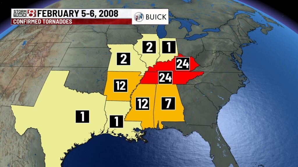

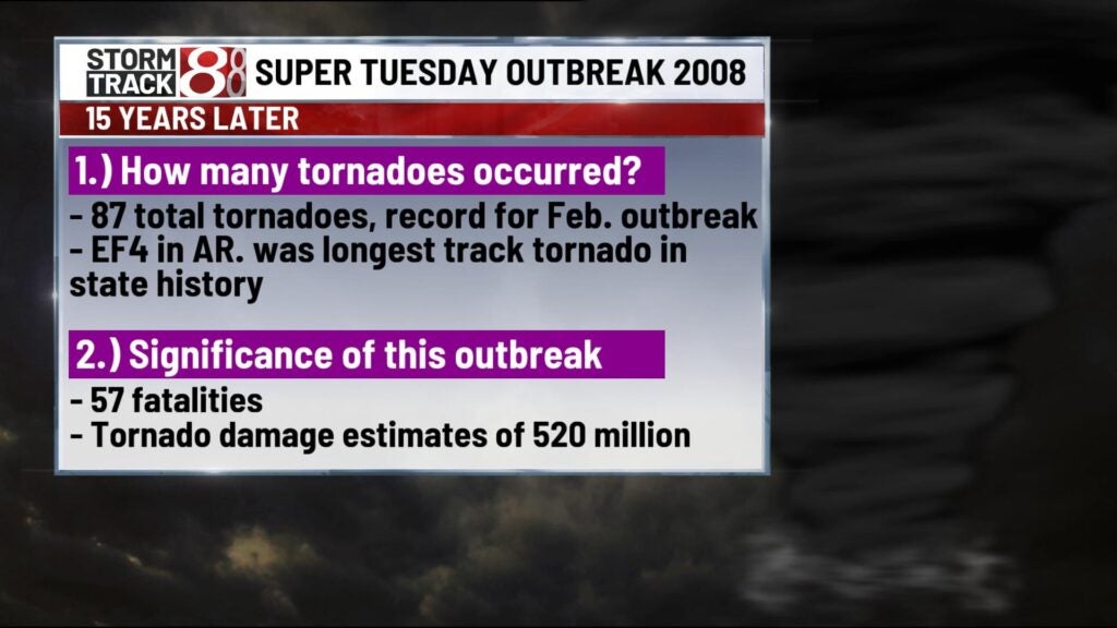
In all, 87 total tornadoes were recorded from this outbreak which is the largest February tornado outbreak in history. Unfortunately from this 2-day event, there were 57 fatalities and damage estimates of around 520 million dollars. At the time, this was the deadliest tornado outbreak in the modern NEXRAD radar era that started in 1997.