


Wildfire smoke moving across Indiana
INDIANAPOLIS (WISH) — Wildfires continue to burn on the West Coast, and the upper air pattern across the country has allowed smoke to reach the Midwest.
The Cedar Creek fire in Oregon is one of the large wildfires pumping smoke into the atmosphere. On Wednesday, the smoke was being picked up on visible satellite imagery across the northern Midwest.

The thickest smoke extends from the Pacific Northwest into Canada and back into the Midwest. The jet stream is directing the smoke in this direction with upper-level, north-to-northwest flow back into our area.

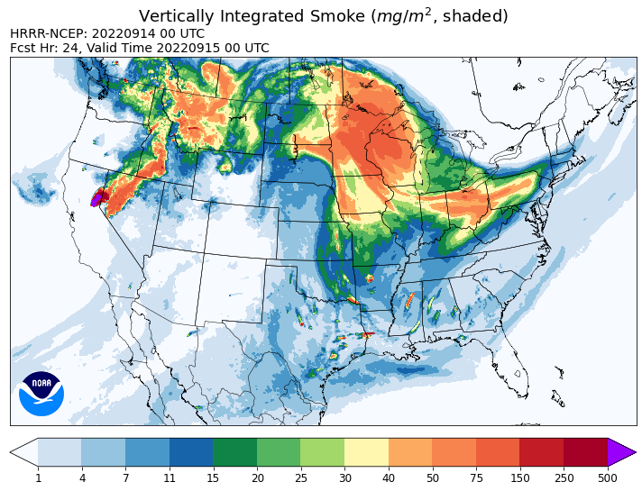
The vertically integrated smoke model is predicting for smoke to increase through late Wednesday into Thursday night for the Midwest. This model measures smoke not only at the surface, but smoke into the upper levels of the atmosphere. Northern Indiana seems to be the spot that this model is indicating could see some denser smoke high up in the air during this time frame. Central Indiana is still likely to see some smoke that is moderate and potentially thick at times. Smoke levels in the atmosphere will lower once we do get closer to the weekend.


From late Wednesday to Thursday night, skies could look a little milky or hazy if the wildfire smoke settles in. This smoke should remain in the upper levels of the atmosphere, which wouldn’t affect air quality that much. However, if the smoke is able to mix down to the surface, then air quality would worsen. Beautiful colors should be seen at sunrise and sunset from the smoke, so get your cameras ready.
