
Weather blog: storm, tornado warnings fill night
Interactive radar | Latest forecast | Download the WISH-TV weather app
11:46 p.m.
Randolph County Health Department reports at least three people died in the tornado. Just after midnight, Indiana State Police said it could not yet confirm reports of fatalities.
11:21 p.m.
U.S. Sen. Mike Braun, a Republican serving Indiana, says on social media, “Please join me in praying for the families of the Hoosiers killed in the tornado in Randolph County, the police, fire, EMS, and linemen responding to the severe weather, and all Hoosiers affected by tonight’s storms.”
Randolph County authorities and Indiana State Police have yet to confirm any deaths to News 8.
11:04 p.m.
Indiana Gov. Eric Holcomb says on social media, “Janet & I send our deepest condolences & prayers to the loved ones of those impacted by tonight’s storms & the Hoosiers in the path of destruction. The people of Winchester are resilient & should know the state will walk alongside & support them as we pick up the pieces & rebuild”
10:55 p.m.
Sgt. Scott Keegan said on Indiana State Police, “Indiana State Police are currently assisting local search and rescue efforts in the City of Winchester after a possible tornado touchdown at approximately 7:59pm. We are requesting the public to avoid the area. Any civilian volunteers can go to White River Vol. Fire Dept.” That Randolph County fire department’s station is located at 1023 N. Old U.S. 27 in northern Winchester.
10:45 p.m.
Randy Ried, fire chief of Liberty Township Fire Department, tells News 8’s Andrew Chernoff in Selma that injuries from the tornado in the Delaware County town were minor. About 20 minutes after the tornado hit, authorities had found everyone who had been inside homes. Damage was severe, the chief says, and a cleanup up effort was expected to being Friday morning. Selma Elementary School was opened to serve as shelter for people who need it.
10:42 p.m.
Tornado warning for Martin County until 11 p.m.

10:35 p.m.
Tornado warning for Daviess and Martin counties until 11 p.m.

10:30 p.m.
Matt True, director of Jefferson County Emergency Management, told News 8 that two people received minor injuries. The tornadoes — True believes there were three — damaged 97 structures, including 29 homes. Most of the damage was in and around the town of Hanover, and near the town of Brooksburg.
10:29 p.m.
Severe thunderstorm warning for Martin and Lawrence counties until 10:45 p.m.

10:21 p.m.
News 8’s Danielle Zulkoksy reports from Winchester that the Taco Bell restaurant was destroyed in the tornado on Thursday night. Downed buildings, power lines, and trees were visible all over.
10:15 p.m.
Three school districts serving Delaware and Randolph counties have reported to WISHTV.com that they will be closed Friday: Liberty-Perry Schools, Monroe Central Schools, and Randolph Southern Schools. Delaware Community Schools will delay its start by two hours.
10:13 p.m.
Severe thunderstorm warning for Knox and Daviess counties until 10:30 p.m.

10:09 p.m.
Severe thunderstorm warning for Martin, Greene, Monroe and Lawrence counties until 10:45 p.m.

10:04 p.m.
Tornado warning for Knox County until 10:15 p.m.

10:01 p.m.
News release from Delaware County Emergency Management Agency:
“Delaware County Emergency Management Agency Responds to Severe Weather Event
“Delaware County, March 14th, 2024 – In the wake of a severe thunderstorm and tornado that swept through Delaware County early this evening, the Delaware County Emergency Management Agency (DCEMA) is actively engaged in response efforts to address the impacts of the disaster.
“Reports indicate that the storm system inflicted significant damage across various parts of the county, with particular emphasis on the town of Selma. Initial assessments suggest that up to 50% of structures in Selma have been damaged. However, we are relieved to report that only minor injuries have been reported thus far, with one individual transported to the hospital for treatment.”
“The Emergency Operations Center (EOC) has been activated and is fully staffed to coordinate response efforts. Public safety agencies are diligently working to assess the extent of damage and injuries, with a primary focus on immediate assistance and support for affected communities.
“In response to the situation in Selma, debris removal operations have commenced, and a comprehensive damage assessment will follow once initial response activities are completed. Additionally, a Reunification Center has been established at Wapahani High School to provide assistance and support for those in the Selma area who may have been displaced or separated from loved ones.
“We have also received reports of serious damage and injuries in the Winchester area of Randolph County. Our thoughts are with those affected, and we are coordinating with relevant authorities to provide assistance and support as needed.
“As part of our efforts to streamline damage assessment, we encourage residents of Delaware County to report property damage through a designated form located at bit.ly/sendyourdamage. Your cooperation will greatly assist us in gauging the full extent of damages and allocating resources effectively.
“The safety and well-being of our residents remain our top priority, and we will continue to provide updates as new information becomes available. We extend our gratitude to the dedicated first responders, volunteers, and community members who are working tirelessly to support those impacted by this devastating event.
“For further information and updates, we will be releasing further Information on our Social Media.”
Delaware County Emergency Management Agency
9:54 p.m.
Severe thunderstorm warning for Knox, Greene and Owen counties until 10:15 p.m.

9:51 p.m.
A total of 5,550 of Indiana-Michigan’s 10,942 customers in Randolph County were without power.
9:49 p.m.
Severe thunderstorm warning for Shelby County until 10:15 p.m.

9:47 p.m.
Severe thunderstorm warning for Decatur, Rush and Shelby counties until 10:30 p.m.

9:44 p.m.
Tornado warning for Knox County until 10:15 p.m.

9:41 p.m.
Tornado warning for Knox County until 10:15 p.m.

9:33 p.m.
Severe thunderstorm warning for Morgan, Johnson, Monroe and Brown counties until 10 p.m.

9:31 p.m.
Severe thunderstorm warning for Daviess and Martin counties until 10:30 p.m.

9:26 p.m.
Winchester Community High School has been opened to help people who need emergency assistance, emergency officials say.
Ascension St. Vincent Randolph hospital in Winchester is open and available to care for patients.
9:17 p.m.
Severe thunderstorm warning for Morgan and Monroe counties until 9:45 p.m.

9:16 p.m.
Severe thunderstorm warning for Brown, Johnson, Monroe and Morgan until 10 p.m.

9:07 p.m.
Tornado warning in Owen County until 9:30 p.m.

8:58 p.m.
Tornado warning for Owen County until 9:30 p.m.

8:54 p.m.
Severe thunderstorm warning for Owen and Morgan counties until 9:45 p.m.

8:44 p.m.
Severe thunderstorm warning for Hendricks, Marion and Morgan counties until 9:30 p.m.

8:40 p.m.
Severe thunderstorm warning for Vigo County until 9:15 p.m.

8:39 p.m.
Severe thunderstorm warning for Marion, Morgan and Johnson counties until 9:15 p.m.

8:31 p.m.
Tornado warning for Henry County until 9 p.m.

8:23 p.m.
Severe thunderstorm warning for Hamilton, Marion, Madison and Henry counties until 8:23 p.m.

8:20 p.m.

8:19 p.m.
Severe thunderstorm warning until 8:30 p.m.

8:14 p.m.
Severe thunderstorm warning in Boone and Hamilton counties until 8:30 p.m.

8:10 p.m.
Severe thunderstorm warning in Madison and Henry counties until 8:45 p.m.

8:07 p.m.
Radar-confirmed tornado in Randolph County. Tornado warning through 8:45 p.m. This is a life-threatening situation.

8:05 p.m.
Radar-confirmed tornado in Randolph County. Tornado warning through 8:45 p.m. This is a life-threatening situation.

8:03 p.m.
Severe thunderstorm warning in Hamilton and Madison counties until 8:45 p.m.

7:55 p.m.
Severe thunderstorm warning in Vigo, Vermillion and Parke counties until 8:30 p.m.

7:52 p.m.
Severe thunderstorm warning in Boone and Hamilton counties until 8:30 p.m.

7:50 p.m.
Severe thunderstorm warning in Morgan and Owen counties until 8:30 p.m.

7:49 p.m.
Tornado warning for Randolph County until 8:30 p.m.

7:40 p.m.
Tornado warning for Delaware and Randolph counties until 8:30 p.m.

Severe thunderstorm warning in Hamilton, Hancock and Madison counties until 8:15 p.m.

7:39 p.m.
Photos of hail in Westfield from WISH-TV’s Sacha Ballou.

7:36 p.m.
Severe thunderstorm warning in Boone and Montgomery counties until 8 p.m.

7:35 p.m.
Severe thunderstorm warning in Hamilton County until 7:45 p.m.

7:30 p.m.
WISH-TV interactive radar at 7:30 p.m.

7:29 p.m.
Tornado warning for Delaware County until 7:45 p.m.

Severe thunderstorm warning for Hamilton and Madison counties until 8 p.m.

7:22 p.m.
Tornado warning for Delaware County until 7:45 p.m.

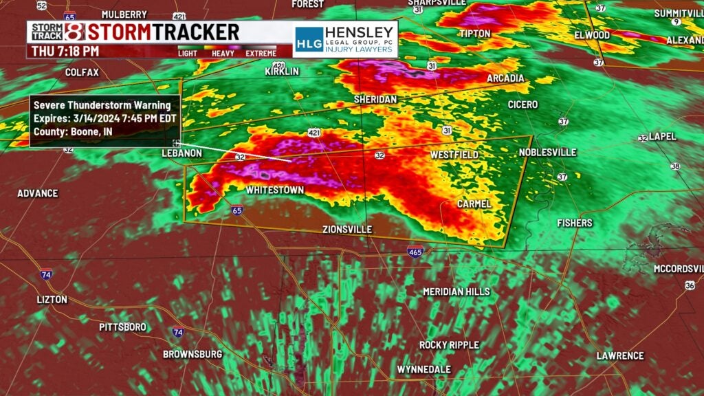
7:18 p.m.
A severe thunderstorm warning for Delaware and Madison counties until 7:45 p.m.

7:16 p.m.
A severe thunderstorm warning for Boone and Hamilton counties until 7:45 p.m.

7:11 p.m.
A severe thunderstorm warning for Clinton and Boone counties until 7:30 p.m.

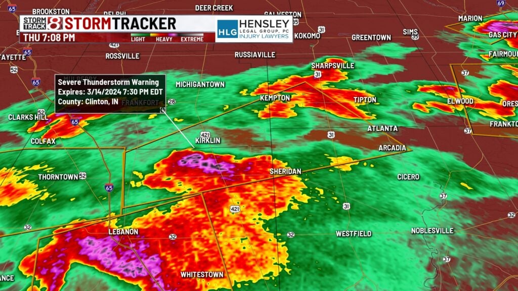
7:08 p.m.
A severe thunderstorm warning for Boone County until 7:15 p.m.

7:05 p.m.
A severe thunderstorm warning for Boone, Clinton, Hamilton and Tipton counties until 7:30 p.m.

A severe thunderstorm warning for Delaware and Madison counties until 7:45 p.m.

6:55 p.m.
A severe thunderstorm warning for Montgomery and Boone counties until 7:30 p.m.

6:51 p.m.
Indiana is no longer under any tornado warnings, Storm Track 8 Chief Meteorologist Ashley Brown reports.
A severe thunderstorm warning for Tipton County until 7 p.m. The storm contains baseball-sized hail.

6:50 p.m.
Severe thunderstorm warning for Grant County until 7:15 p.m. The storm contains golf ball-sized hail.

6:44 p.m.
Severe thunderstorm warning for Huntington and Wabash counties until 7 p.m.

6:43 p.m.
Severe thunderstorm warning for Howard and Tipton counties until 7 p.m. The storm contains baseball-sized hail.

6:42 p.m.
Severe thunderstorm warning for Blackford, Grant and Wells counties until 7 p.m.

6:39 p.m.
Tornado warning for Adams County until 7 p.m.

6:37 p.m.
Severe thunderstorm warning for Clinton, Howard and Tipton counties until 7 p.m. The storm contains baseball-sized hail.

6:34 p.m.
Severe thunderstorm warning for Blackford, Grant and Wells counties until 7 p.m.

6:33 p.m.
Tornado warning for Adams County until 7 p.m.

Severe thunderstorm warning For Clinton, Howard and Tipton counties until 7 p.m. The storm contains baseball-sized hail.

6:31 p.m.
Severe thunderstorm warning for Miami, Huntington and Wabash counties until 7 p.m.

6:27 p.m.
Tornado warning for Adams and Wells counties until 7 p.m.

6:24 p.m.
Severe thunderstorm warning for Blackford, Grant and Wells counties until 7 p.m.

6:23 p.m.
Severe thunderstorm warning for Clinton, Howard and Tipton counties until 7 p.m.

6:22 p.m.
Tornado warning for Wells County until 6:45 p.m.

6:17 p.m.
A severe thunderstorm warning for northeastern Grant and southern Huntington counties until 6:30 p.m.

6:16 p.m.
Severe thunderstorm warning for Tipton County until 6:45 p.m.

6:15 p.m.
A tornado warning for southern Wells County until 6:45 p.m. Ping-pong ball-sized hail is possible.

6:10 p.m.
A severe thunderstorm warning was issued for Tipton County until 6:45 p.m. The storm contains 2-inch-diameter hail.

6:08 p.m.
A severe thunderstorm warning was issued for Tipton County and southeastern Howard County until 6:45 p.m. The storm contains large hail.

A severe thunderstorm warning was issued for northern Grant, southeastern Wabash and southwestern Huntington counties until 6:30 p.m.

6:06 p.m.
A severe thunderstorm warning was issued for northeastern Grant, southern Wells and southeastern Huntington counties until 6:30 p.m.

6:02 p.m.
A severe thunderstorm warning was issued for northern Boone and southern Tipton counties until 6:45 p.m. The storm contains golf ball-sized hail.

5:58 p.m.
A severe thunderstorm warning was issued for northeastern Grant, southern Wells and southern Miami counties until 6:30 p.m.

5:50 p.m.
A tornado warning was issued for northeastern Grant, southwestern Wells and southern Huntington counties until 6:15 p.m.

5:47 p.m.
A severe thunderstorm warning for southern Miami, southwestern Wabash and northwestern Grant counties until 6:15 p.m. Primary threats are winds up to 60 mph and quarter-sized hail.

5:35 p.m.
Tornado warning for northern Grant and southern Wabash counties until 6:15 p.m. EDT. At 5:35 p.m. EDT, a severe thunderstorm capable of producing a tornado was located over Sweetser, or near Marion, moving east at 40 mph. Primary hazards were a tornado and quarter-sized hail.

5:21 p.m.
A tornado watch has been issued until midnight EDT Thursday and 11 p.m. CDT Thursday for most of central Indiana and parts of northern and southern Indiana.
Large Indiana cities in the watch area include Indianapolis, Fort Wayne, Lafayette, Muncie and Terre Haute.
Here is the list of Indiana counties in the watch from the National Weather Service’s Storm Prediciton Center in Norman, Oklahoma: Adams, Allen, Bartholomew, Blackford, Boone, Brown, Carroll, Cass, Clay, Clinton, Daviess, Dearborn, Decatur, Delaware, Fayette, Fountain, Franklin, Grant, Greene, Hamilton, Hancock, Hendricks, Henry, Howard, Huntington, Jackson, Jay, Jennings, Johnson, Knox, Lawrence, Madison, Marion, Martin, Miami, Monroe, Montgomery, Morgan, Orange, Owen, Parke, Putnam, Randolph, Ripley, Rush, Shelby, Sullivan, Tippecanoe, Tipton, Union, Vermillion, Vigo, Wabash, Warren, Wayne, Wells and White.
Tornado watches also were in effect for much of central Illinois and western Ohio.
A tornado touched down on Tuesday afternoon in Jefferson County, Indiana, Storm Track 8 has reported. That’s on the Ohio River about halfway between Louisville, Kentucky, and Cincinnati.