
What we know about 23 tornadoes that hit Indiana on March 31-April 1, 2023
(WISH) — The National Weather Service has reported 23 tornadoes hit Indiana on the night of March 31 and the early morning of April 1.
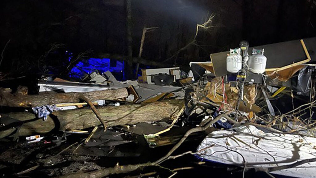
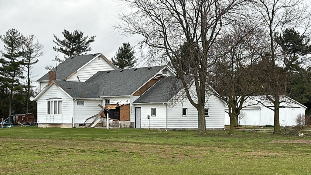
Five people died and 11 were injured, based on weather service reports through Tuesday evening. While many homes, farms and businesses were destroyed and damaged, the devastation included Amish barns, a large irrigation system, giant wind turbines, and Indiana’s oldest state park.
The 23rd tornado, in Porter County, was confirmed April 9 by the weather service office in Chicago.
The tornado outbreak is Indiana’s fifth largest, Storm Track 8’s Ryan Morse reports.
Here are details, as recorded through Tuesday evening, from the weather service surveys on each tornado.
Times are Eastern.
1. 9:28-9:42 p.m., Fowler, Benton County
- Estimated peak winds: 120 mph (Enhanced Fujita scale rating of EF-2).
- Injuries/deaths: none.
- Path length: 12.5 miles.
- Maximum width: 400 yards.
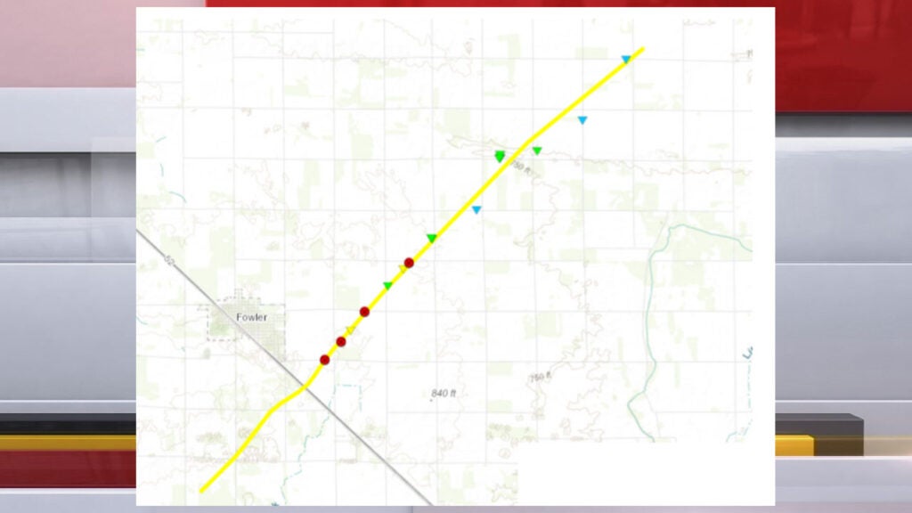
The tornado began southwest of the town of Fowler. The tornado destroyed several outbuildings, and damaged a wind farm and homes east of Fowler.
2. 9:33-9:47 p.m., from near Oxford to near Brookston, Benton and White counties (northwest of Badger Grove)
- Estimated peak winds: 115 mph (Enhanced Fujita scale rating of EF-2).
- Injuries/deaths: none.
- Path length: 15.18 miles.
- Maximum width: 400 yards.

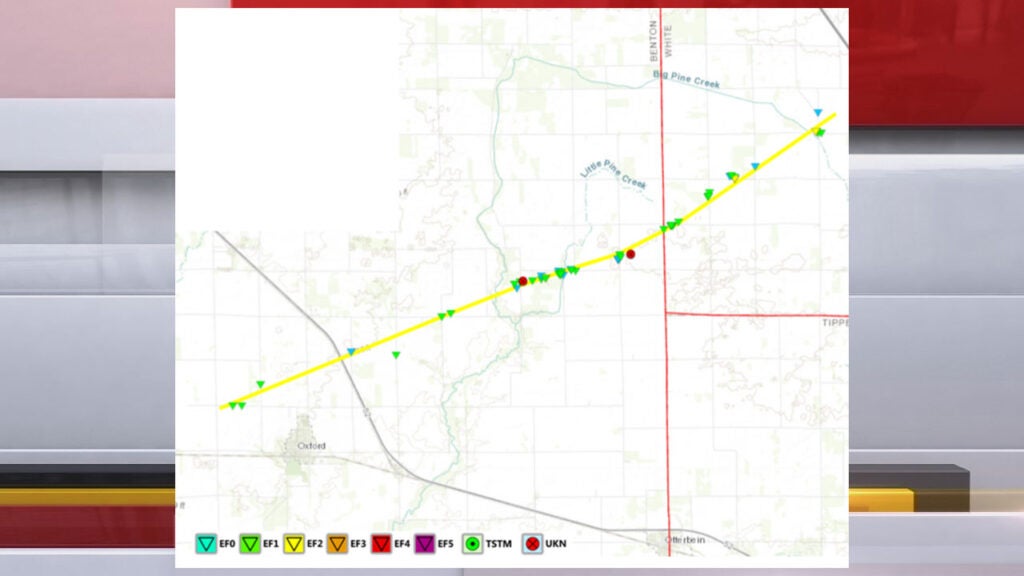
The tornado touched down about a mile northwest of the Benton County town of Oxford and ended about 8 miles northwest of the town of Brookston in White County, or 4 miles northwest of the unincorporated community of Badger Grove. Several homes were damaged; two were destroyed. Other damage included utility poles and farm outbuildings.
3. 9:41-9:50 p.m.: near Goodland and Remington, Benton County
- Estimated peak winds: 105 mph (EF-1).
- Injuries/deaths: none.
- Path length: 10.3 miles.
- Maximum width: 500 yards.
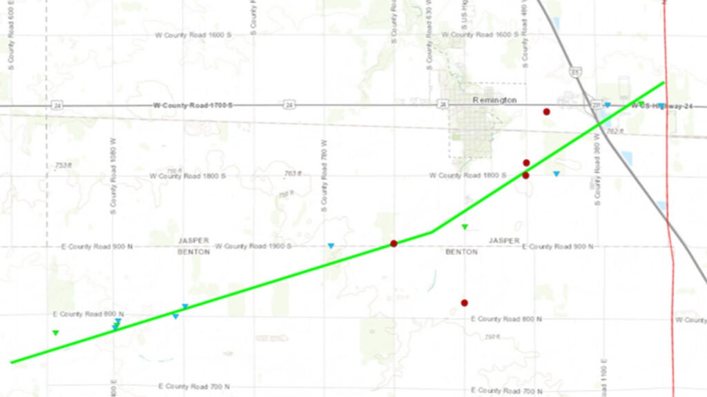
The tornado touched down southwest of the intersection of East Benton County Road 800 North and North County Road 300 East, about 3 miles south of the town of Goodland. The tornado damaged small farm outbuildings, utility poles and trees. The storm also crossed I-65 near the U.S. 231 interchange. The tornado lifted north of the intersection of South County Road 280 West just north of U.S. 231, about a mile east of the I-65 interchange.
4. 9:53-10 p.m., Merrillville to Hobart, Lake County
- Estimated peak winds: 105 mph (EF-1).
- Injuries/deaths: none.
- Path length: 4.2 miles.
- Maximum width: To be determined.
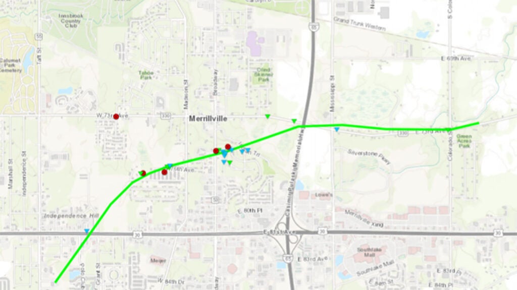
The National Weather Service at Chicago has confirmed a EF-1 tornado moved from the Merrillville area to the Hobart area in Lake County. No addition details were available Tuesday afternoon.
5. 9:55-9:58 p.m., near Smithson, White County
- Estimated peak winds: 85 mph (EF-0).
- Injuries/deaths: none.
- Path length: 1.29 miles.
- Maximum width: 125 yards.
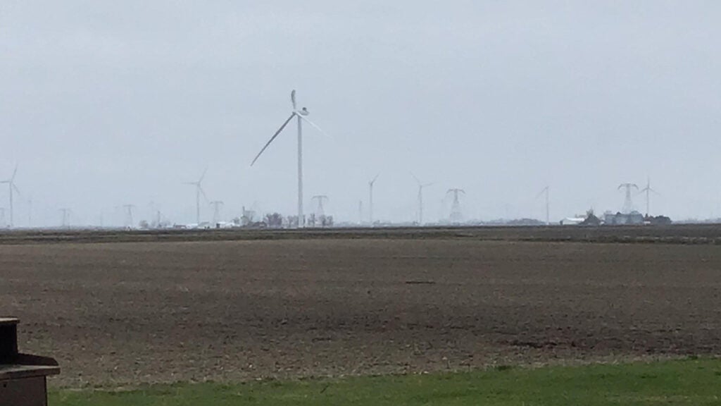
A tornado touched down in an open field south of West Smithson Road and west of South County 75 West near the unincorporated community of Smithson. That’s about a mile south of the town of Reynolds. On wind turbines, the tornado torn off one blade and bent another. The tornado later damaged a pole barn and threw two empty silos into a nearby field.
6. 10:01-10:02 p.m., near Shorewood Forest, Porter County
- Estimated peak winds: 70 mph (EF-0).
- Injuries/deaths: none.
- Path length: 0.6 miles.
- Maximum width: 125 yards.
The brief tornado damaged trees, outbuildings and farm equipment in its short track northeast of the unincorporated community of Shorewood Forest. The tornado began on West Porter County Road 350 North west of the intersection with North County Road 650 West. That’s about 4 miles west of Valparaiso.
7. 10:13-10:16 p.m., southwest of Royal Center, Cass County
- Estimated peak winds: 100 mph (EF-1).
- Injuries/deaths: none.
- Path length: 1.73 miles.
- Maximum width: 300 yards.
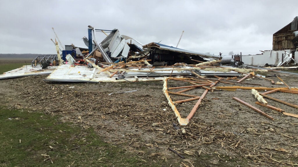
The tornado touched down in an open field south of West County Road 400 North between north county roads 1000 West and 925 West. That’s about 3 miles southwest of the town of Royal Center. The tornado flipped eight spans of a center-pivot irrigation system, and destroyed two large pole barns at a home near 400 North and 925 West. Also at that location, several trees were snapped. The back garage portion of a home was damaged. Power poles were snapped in the area. The tornado made a turn and began to weaken, but not before it lifted part of the roof off a home at the intersection of West County Road 400 North and North County Road 900 West.
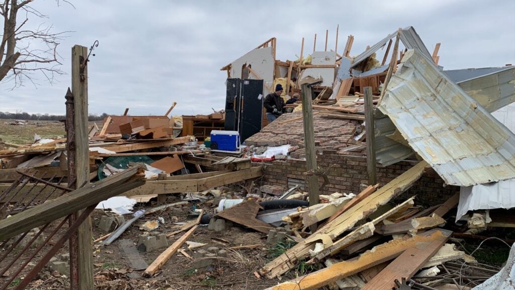
8. 10:21 p.m., Sullivan County
- Estimated peak winds: 115 mph (EF-3).
- Injuries/deaths: three fatalities, eight injuries.
- Path length (in Indiana only): 13.15 miles.
- Maximum width: 660 yards (three-eights of a mile).
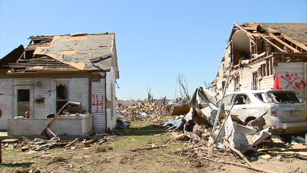
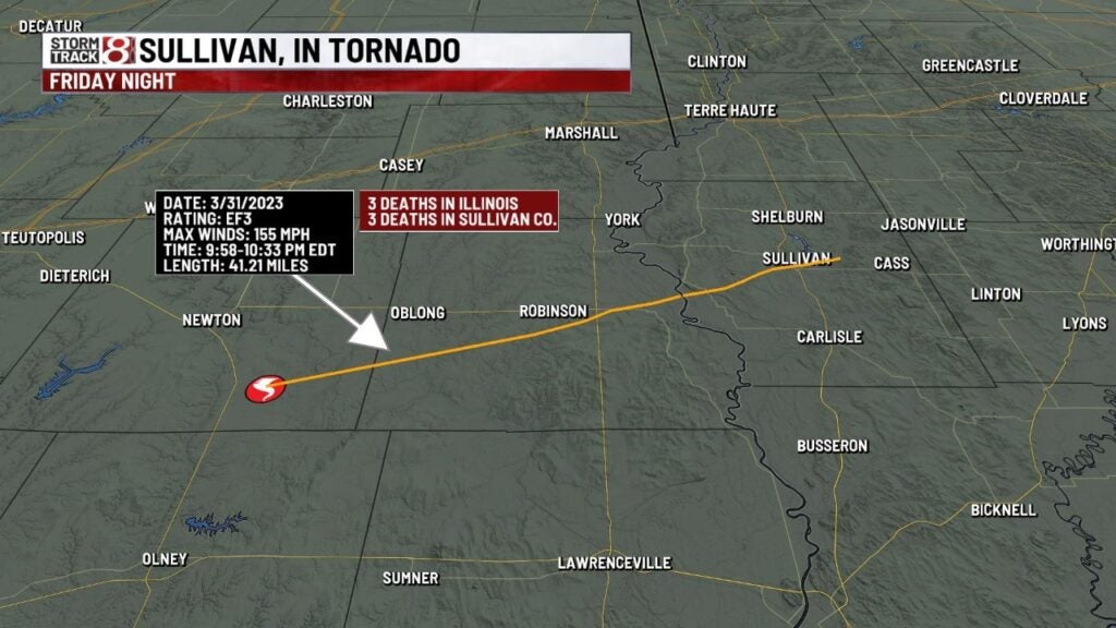
Indiana saw 13.15 miles of a 40-mile tornado path that crossed the Wabash River from Illinois and entered Sullivan County about 3 miles east-northeast of Merom.
Near Merom, the tornado threw and destroyed a modular home, and damaged three homes. Two people were killed. A large trailer and several cars were strewn through tens of yards. Many trees were sheared approximately 20 to 30 feet off the ground.
In Sullivan, “tens of homes and structures were severely damaged or destroyed,” the weather service says.
Southeast of Sullivan, three more homes were destroyed. An occupant of a modular home was killed and another occupant was injured. Many trees were sheared 20 to 30 feet off the ground.
Further east, the tornado damaged trees before lifting.
The Sullivan County Coroner’s Office says these Sullivan area residents died in the storm: Susan Kay Horton, 61; Thomas Randall Horton, the son of Susan Horton, 38; and Shane Steven Goodman, 47.
On Monday, News 8’s Camila Fernandez visited Sullivan for the latest report.
9. 10:43 p.m., Montgomery and Boone counties
- Estimated peak winds: 85 mph (EF-0).
- Injuries/deaths: none.
- Path length: 1.77 miles.
- Maximum width: 50 yards.

A weaker, secondary tornado track tornado partially destroyed a barn in Montgomery County near the Boone County line; debris was thrown up to a quarter-mile. Also, another older barn shifted from its foundation. Tree damage also was reported from the tornado.
10. 10:43 p.m., near Colfax, Montgomery, Boone and Clinton counties*
- Estimated peak winds: 120 mph (EF-2).
- Injuries/deaths: none.
- Path length: 10.55 miles.
- Maximum width: 100 yards.

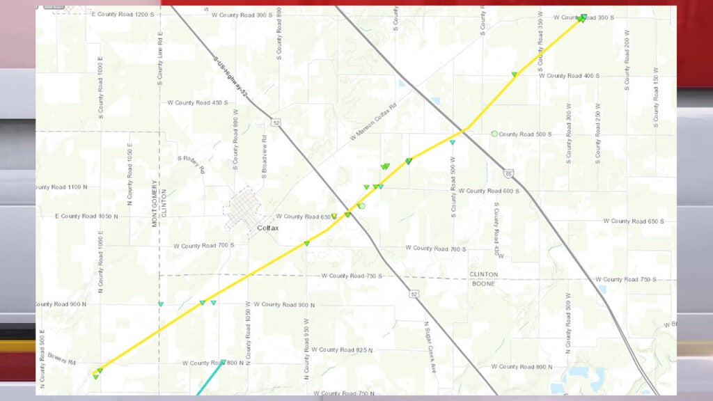
* The National Weather Service has updated the original map and information first published with this tornado, including the length of its path.
The tornado began in northeast Montgomery County, southwest of Colfax, and damaged trees and a couple of barns. Northeast of Colfax, the tornado and impacted a large homestead with a barn, and toppled a large radio tower. The tornado then moved through portions of rural southwestern Clinton County causing damage to farmsteads. A few barns between U.S. 52 and I-65 were completely destroyed. Next, the tornado only caused minor damage for a short period of time before doing additional significant damage southwest of Frankfort.
The National Weather Service has updated the original map published with this tornado.
11. 11:01 p.m., McCormick’s Creek State Park, Owen and Monroe counties
- Estimated peak winds: 138 mph (EF-3).
- Injuries/deaths: two fatalities, two injuries.
- Path length: 4.01 miles.
- Maximum width: 400 yards.
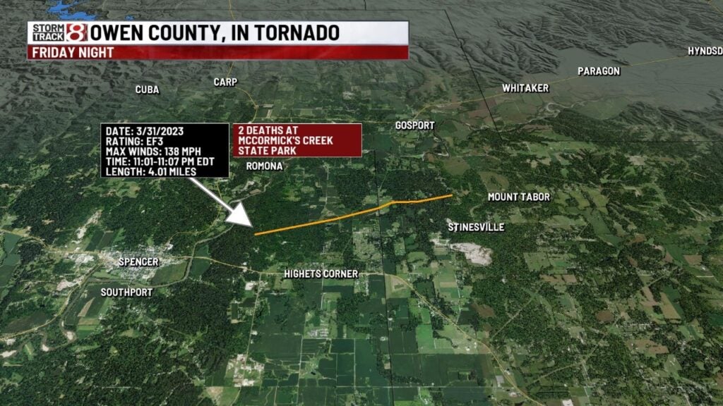
The tornado began in McCormick’s Creek State Park, snapping and, in some cases, removing the bark from trees. A few homes were badly damaged or destroyed. Both fatalities were in McCormick’s Creek State Park, which was closed after the storm. McCormick’s Creek State Park is the oldest state park, dedicated on July 4, 1916. Indiana Department of Natural Resources say Brett Kincaid, 53, and Wendy Kincaid, 47, both of Rossville, Indiana, died in the storm.
12. 11:11 p.m., near Russiaville, Howard County
- Estimated peak winds: 80 mph (EF-0).
- Injuries/deaths: none.
- Path length: 0.86 miles.
- Maximum width: 10 yards.
The tornado touched down in a field with a few trees just southwest of the intersection of West County Road 500 South and South County Road 750 West. The tornado impacted a home and caused tree and barn damage. One treetop was pulled back toward the home. The tornado then lifted in a nearby farm field.
13. 11:15 p.m., near Russiaville, Howard County
- Estimated peak winds: 80 mph (EF-0).
- Injuries/deaths: none.
- Path length: 0.14 miles.
- Maximum width: 10 yards.
The tornado touched down around the intersection of West Howard County Road 350 South and South County Road 350 West, and damaged an outbuilding and a homestead. An attached garage and a few small sheds were damaged east of County Road 350 West. Also found at this weather service survey: A car was turned 45 degrees; a large piece of plywood was stuck between remaining tree branches; and wooden splinters were driven into siding.
14. 11:20 p.m., near Greentown, Howard County
- Estimated peak winds: 110 mph (EF-1).
- Injuries/deaths: one injury.
- Path length: 6.41 miles.
- Maximum width: 25 yards.
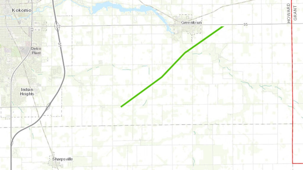
The tornado began in a field south of a homestead with two barns, a home and a mobile home. One small barn and the mobile home were destroyed. The injury happened in the mobile home. The home and larger barn had lesser damage. The tornado later damaged trees, and other barns and homes. A neighborhood near County Road 100 South suffered roof and tree damage.
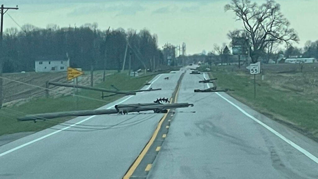
15. 11:21 p.m., near Martinsville, Morgan County
- Estimated peak winds: 130 mph (EF-2).
- Injuries/deaths: none.
- Path length: 8.6 miles.
- Maximum width: 200 yards.
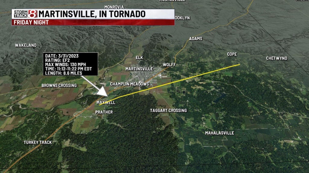
The tornado touched down in a subdivision south of Martinsville and west of State Road 37 near the unincorporated community of Maxwell. Several homes received roof damage. Also, an empty grain bin was lofted and displaced, and its top was torn off.
The tornado damaged trees only until reaching Rolling Hills Drive, where a pontoon boat was lofted across a lake and over a house, landing a quarter-mile from where it was initially.
16. 11:27 p.m., near Bargersville, Johnson County
- Estimated peak winds: 85 mph (EF-0).
- Injuries/deaths: none.
- Path length: 0.86 miles.
- Maximum width: 10 yards.
The tornado formed north-northeast of the unincorporated community of Providence, about a mile south of Bargersville. The tornado damaged trees, power lines, and the metal roofing of a barn. The tornado crossed State Road 135 but lifted before reaching State Road 144.
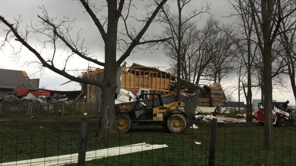
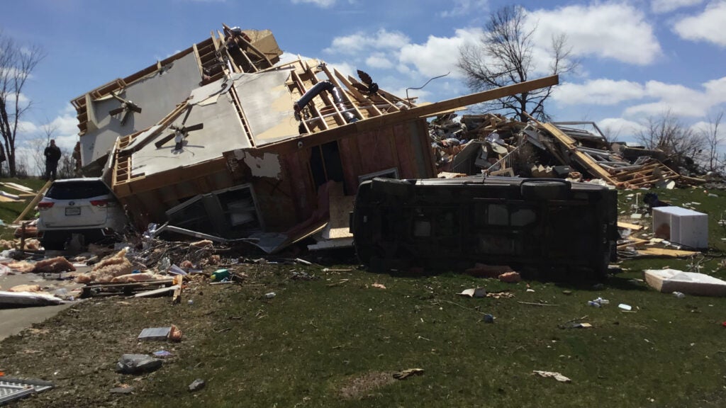
17. 11:33 p.m., Whiteland, Johnson County
- Estimated peak winds: 140 mph. (preliminary EF-3).
- Injuries/deaths: none.
- Path length: 3.54 miles.
- Maximum width: 316 yards.
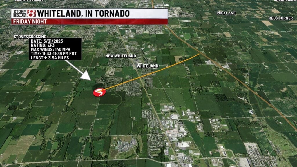
A previous tornado redeveloped in an open field west of Centerline Road and Forest Park South Drive in Whiteland. The tornado intensified as it moved into the Forest Park neighborhood, damaged a cell tower near the Whiteland Sewage Department, crossed U.S. 31, and then moved into a neighborhood off Briar Hill Road.
The tornado then caused more damage in downtown Whiteland and crossed the railroad. The weather service says a poorly constructed home along East Pearl Street was completely destroyed, with only a concrete slab remaining.
The tornado then damaged a home on Whiteland Road before crossing an open field and destroying more homes, and uprooting or snapping trees along Graham Road.
The tornado weakened as it hit a warehouse northeast along Graham Drive. The tornado lifted just east of I-65.
News 8’s Garrett Bergquist reported Monday from Whiteland.
18. 11:33 p.m., Swayzee, Grant County
- Estimated peak winds: 120 mph. (EF-2).
- Injuries/deaths: none.
- Path length: 3.10 miles.
- Maximum width: 150 yards.

The tornado developed south of Grant County Road 300 South west of the town Swayzee and tracked through the community, ending just east of County Road 600 West. Homes and buildings, including Swayzee Elementary School, sustained minor to moderate damage to roofs. Trees and utility poles were snapped or uprooted.
19. 11:36 p.m., Fort Wayne and Harlan, Allen County (3 miles north of New Haven)
- Estimated peak winds: 120 mph. (EF-2).
- Injuries/deaths: none.
- Path length: 7.86 miles.
- Maximum width: 400 yards.
The tornado touched down near the Audubon Park neighborhood on the northeast side of Fort Wayne near the intersection of Maysville Road and Cardinal Lane.
About 2 miles northeast of Fort Wayne in the unincorporated community of Harlan, homes and farms were damaged. Extensive tree damage and powerline damage happened along and south of State Road 37. The most significant damage was observed along Notestine Road.
20. 11:42 p.m., Gas City, Grant County
- Estimated peak winds: 140 mph. (EF-3).
- Injuries/deaths: none.
- Path length: 6.35 miles.
- Maximum width: 200 yards.
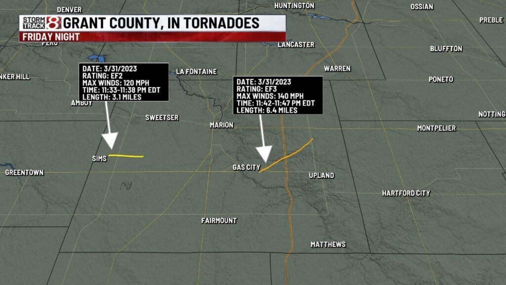
The tornado developed southeast of Gas City, crossing I-69, and then dissipated east of Grant County Road 900 East just south of County Road 100 South.
The hardest hit area was just east off Blackthorn Drive, which is east of Gas City, where several homes were destroyed. Beyond I-69, the tornado damaged to barns, trees and more homes. In several areas, extensive tree damage was noted.
21. 11:44 p.m., Harlan, Allen County
- Estimated peak winds: 75 mph. (EF-0).
- Injuries/deaths: none.
- Path length: 1.14 miles.
- Maximum width: 75 yards.
A short-lived tornado formed from a microburst just south of Antwerp road between Bull Rapids Road and Rupert Road. A home on Rupert Road near Dean Road received roof and siding damage. Several trees were snapped or uprooted.
22. 12:19 a.m., near Salamonia, Jay County
- Estimated peak winds: 85 mph. (EF-0).
- Injuries/deaths: none.
- Path length: 1.54 miles.
- Maximum width: 175 yards.
The tornado touched down at a home south of East County Road 300 South and South County Road 500 East near the town of Salamonia. Debris damaged three newer barns and pushed over grain bins. The tornado crossed East 300 South and also South County Road 600 East before dissipating in a field.
23. 12:20 a.m., near Portland, Jay County
- Estimated peak winds: 80 mph. (EF-0).
- Injuries/deaths: none.
- Path length: 2.44 miles.
- Maximum width: 100 yards.
The tornado touched down near the intersection of North County Road 200 East and East County Road 200 North. Two barns received wall and roof damage, and trees and were broken. The tornado crossed East County Road 300 North before dissipating over a field.